Blue Earth River
| Blue Earth River | |
| River | |
|
The Blue Earth River as viewed from Rapidan Dam in Blue Earth County in 2007
|
|
| Country | United States |
|---|---|
| States | Iowa, Minnesota |
| Tributaries | |
| - left | Watonwan River |
| - right | East Branch Blue Earth River, Le Sueur River |
| Source | Middle Branch Blue Earth River |
| - location | near Rake, Winnebago County, Iowa |
| - elevation | 1,207 ft (368 m) |
| - coordinates | 43°27′30″N 93°48′04″W / 43.45833°N 93.80111°W |
| Secondary source | West Branch Blue Earth River |
| - location | near Swea City, Kossuth County, Iowa |
| - elevation | 1,152 ft (351 m) |
| - coordinates | 43°24′13″N 94°17′38″W / 43.40361°N 94.29389°W |
| Source confluence | |
| - location | Elmore Township, Faribault County, Minnesota |
| - elevation | 1,076 ft (328 m) |
| - coordinates | 43°34′20″N 94°06′11″W / 43.57222°N 94.10306°W |
| Mouth | Minnesota River |
| - location | Mankato, Blue Earth County, Minnesota |
| - elevation | 765 ft (233 m) |
| - coordinates | 44°09′51″N 94°02′13″W / 44.16417°N 94.03694°WCoordinates: 44°09′51″N 94°02′13″W / 44.16417°N 94.03694°W |
| Length | 108 mi (174 km) |
| Basin | 3,486 sq mi (9,029 km2) |
| Discharge | for Rapidan Township, Minnesota |
| - average | 1,076 cu ft/s (30 m3/s) |
| - max | 43,100 cu ft/s (1,220 m3/s) |
| - min | 6.9 cu ft/s (0 m3/s) |
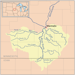
The Blue Earth River is a tributary of the Minnesota River, 108 miles (174 km) long, in southern Minnesota in the United States. Two of its headwaters tributaries, the Middle Branch Blue Earth River and the West Branch Blue Earth River, also flow for short distances in northern Iowa. By volume, it is the Minnesota River's largest tributary, accounting for 46% of the Minnesota's flow at the rivers' confluence in Mankato. Via the Minnesota River, the Blue Earth River is part of the watershed of the Mississippi River, draining an area of 3,486 square miles (9,029 km²) in an agricultural region. Ninety percent of the river's watershed is in Minnesota. It is a Minnesota Department of Natural Resources designated Water Trail.
The river was named for former deposits of bluish-green clay, no longer visible, along the banks of the river. The stream was called Makato Osa Watapa by the Dakota Indians, meaning "the river where blue earth is gathered." The French explorer Pierre-Charles Le Sueur established Fort L'Huillier near the river's mouth in 1700 for the purpose of mining the clay, either in the mistaken belief that the clay contained copper, or as a ruse to secure funding from his patrons for his fur trading activities. The fort was abandoned the following year after an attack by the Fox tribe. In the 19th century, the geographer Joseph Nicollet found cavities from which the clay had been dug by Native Americans in the region, who used it as body paint; he found no evidence of Le Sueur's mines, nor of the fort.
The Blue Earth River begins at the confluence of its west and middle branches, approximately five miles (8 km) north of Elmore in southwestern Faribault County, Minnesota. The Middle Branch, 35.1 miles (56.5 km) long and sometimes known as the main stem of the river, rises in northwestern Winnebago County, Iowa, approximately 7 miles (11 km) east of Rake, and flows westwardly into Kossuth County, Iowa, then northwardly into Faribault County. The West Branch, 24.7 miles (39.8 km) long, rises near Swea City, Iowa, in northern Kossuth County and flows northeastwardly into Faribault County. Both headwaters tributaries have been channelized for much of their courses.
...
Wikipedia


