Watonwan River
| Watonwan River | |
| River | |
|
The Watonwan River in Garden City in 2007
|
|
| Country | United States |
|---|---|
| State | Minnesota |
| Tributaries | |
| - left | North Fork Watonwan River |
| - right | South Fork Watonwan River |
| Source | |
| - location | Amboy Township, Cottonwood County |
| - elevation | 1,529 ft (466 m) |
| - coordinates | 44°01′30″N 95°13′12″W / 44.02500°N 95.22000°W |
| Mouth | Blue Earth River |
| - location | Rapidan Township, Blue Earth County |
| - elevation | 879 ft (268 m) |
| - coordinates | 44°04′13″N 94°07′35″W / 44.07028°N 94.12639°WCoordinates: 44°04′13″N 94°07′35″W / 44.07028°N 94.12639°W |
| Length | 113.2 mi (182 km) |
| Basin | 878 sq mi (2,274 km2) |
| Discharge | for near Garden City |
| - average | 391 cu ft/s (11 m3/s) |
| - max | 13,900 cu ft/s (394 m3/s) |
| - min | 1.8 cu ft/s (0 m3/s) |
|
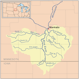
Map of the Blue Earth watershed that shows the Watonwan River
|
|
The Watonwan River is a tributary of the Blue Earth River, 113 miles (182 km) long, in southern Minnesota in the United States. Via the Blue Earth and Minnesota rivers, it is part of the watershed of the Mississippi River, draining an area of 878 square miles (2,270 km2) in an agricultural region. The Watonwan drains about a quarter of the Blue Earth River's watershed.
The river was the site of the capture of Bob, Cole and Jim Younger (members of the James–Younger Gang) near Madelia in 1876.
The Watonwan River rises in Amboy Township, approximately 3 miles (5 km) southwest of Jeffers in central Cottonwood County, and flows generally eastwardly across flat till plains through northern Watonwan and western Blue Earth counties, past the city of Madelia. It flows into the Blue Earth River approximately 8 miles (13 km) southwest of Mankato and 16 miles (26 km) upstream of the Blue Earth's confluence with the Minnesota River.
The river's largest tributaries are its north and south forks. The South Fork Watonwan River, 73 miles (117 km) long, rises in southeastern Cottonwood County and initially flows eastwardly into southern Watonwan County, briefly entering Martin County and passing Odin; then northeastwardly through eastern Watonwan County to its confluence with the Watonwan River upstream of Madelia. The North Fork Watonwan River, 39 miles (63 km) long, rises in Cottonwood County and flows eastwardly into northern Watonwan County, joining the Watonwan River about a mile (2 km) southeast of La Salle.
...
Wikipedia


