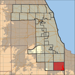
Bloom Township, Cook County, Illinois
| Bloom Township | |
|---|---|
| Township | |
 Location in Cook County |
|
 Cook County's location in Illinois |
|
| Coordinates: 41°31′02″N 87°36′03″W / 41.51722°N 87.60083°WCoordinates: 41°31′02″N 87°36′03″W / 41.51722°N 87.60083°W | |
| Country | United States |
| State | Illinois |
| County | Cook |
| Area | |
| • Total | 46.7 sq mi (121.0 km2) |
| • Land | 46.4 sq mi (120.3 km2) |
| • Water | 0.3 sq mi (0.7 km2) 0.59% |
| Elevation | 630 ft (192 m) |
| Population (2010) | |
| • Total | 90,923 |
| • Density | 1,958/sq mi (755.8/km2) |
| Time zone | CST (UTC-6) |
| • Summer (DST) | CDT (UTC-5) |
| ZIP codes | 60411, 60422, 60425, 60430, 60438, 60461, 60466, 60475, 60476 |
| GNIS feature ID | 0428682 |
Bloom Township is one of 29 townships in Cook County, Illinois, USA. As of the 2010 census, its population was 90,923.
According to the United States Census Bureau, Bloom Township covers an area of 46.7 square miles (121.0 km2); of this, 46.4 square miles (120.3 km2) is land and 0.27 square miles (0.7 km2), or 0.59 percent, is water.
The township contains these six cemeteries: Assumption, Bloom Presbyterian, Calvary, Mount Glenwood Memory Gardens, Saint James Catholic and Saint Pauls Evangelical Lutheran.
...
Wikipedia
