Blea Tarn (Langdale)
| Little Langdale | |
|---|---|
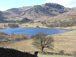
 Little Langdale viewed from Wrynose Pass |
|
| Little Langdale shown within Cumbria | |
| OS grid reference | NY315033 |
| Civil parish |
|
| District | |
| Shire county | |
| Region | |
| Country | England |
| Sovereign state | United Kingdom |
| Postcode district | LA22 |
| Dialling code | 015394 |
| EU Parliament | North West England |
| UK Parliament | |
| Blea Tarn | |
|---|---|

Blea Tarn with Rakerigg, Blake Rigg and Pike of Blisco from Lingmoor Fell
|
|
| Location | Lake District |
| Coordinates | 54°25′49″N 3°5′28″W / 54.43028°N 3.09111°W |
| Type | Tarn |
| Primary outflows | Bleamoss Beck |
| Catchment area | 1.16 km2 (0.45 sq mi) |
| Surface area | 3.48 ha (8.6 acres) |
| Average depth | 7 m (23 ft) |
| Max. depth | 8 m (26 ft) |
| Surface elevation | 230 m (750 ft) / < 190 m (620 ft) (OS map) |
| References | |
| Little Langdale Tarn | |
|---|---|
 |
|
| Location | NY 308032 / NY 309 033 Lake District |
| Coordinates | 54°25′11″N 3°3′58″W / 54.41972°N 3.06611°W |
| Type | infilled glacial valley bottom |
| Primary inflows | River Brathay & Bleamoss Beck, Greenburn Beck |
| Primary outflows | River Brathay |
| Catchment area | 12.0 km2 (4.6 sq mi) |
| Max. length | 375 m (1,230 ft) |
| Max. width | 275 m (902 ft) |
| Surface area | 0.063 km2 (0.024 sq mi), 0.073 km2 (0.028 sq mi) |
| Average depth | 2.7 m (8 ft 10 in) |
| Max. depth | 9.5 m (31 ft) |
| Water volume | 2×10⁶ m3 (1,600 acre·ft) (see note) |
| Residence time | 2 days 3.3 days |
| Surface elevation | 103 m (338 ft) |
Little Langdale is a valley in the Lake District, England containing Little Langdale Tarn and a hamlet also called Little Langdale. A second tarn, Blea Tarn, is in a hanging valley between Little Langdale and the larger Great Langdale to the north. Little Langdale is flanked on the south and southwest by Wetherlam and Swirl How, and to the north and northwest by Lingmoor Fell and Pike of Blisco. The valley descends to join with Great Langdale above Elter Water.
Langdale was previously known as Langdene meaning 'far away wooded valley' and referring to its distance along the flint route from Whitley Bay.
Historically Little Langdale was at the intersection of packhorse routes leading to Ravenglass, Whitehaven, Keswick, Penrith & Carlisle, Ambleside, Hawkshead, and Coniston, Ulverston, Broughton-in-Furness and Barrow in Furness. Slater's Bridge which crosses the River Brathay in 3 spans supported by a large mid-stream boulder and stone causeways is a 16th-century, slate-built, former packhorse bridge on one of these routes. Today metalled roads from Little Langdale lead west over Wrynose Pass and Hardknott towards Eskdale, northwest by Blea Tarn to Great Langdale, northeast to Elterwater and east to the Skelwith Bridge - Coniston road.
...
Wikipedia

