Wetherlam
| Wetherlam | |
|---|---|

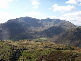
Wetherlam on the left, seen from Lingmoor Fell
|
|
| Highest point | |
| Elevation | 763 m (2502 ft) |
| Prominence | c. 145 m |
| Parent peak | Coniston Old Man |
| Listing | Wainwright, Hewitt, Nuttall |
| Geography | |
| Location | Cumbria, England |
| Parent range | Lake District, Southern Fells |
| OS grid | NY288011 |
| Topo map | OS Landranger 89, 90, Explorer OL6 |
| Listed summits of Wetherlam | ||||
| Name | Grid ref | Height | Status | |
|---|---|---|---|---|
| Black Sails | NY282007 | 745 m (2,444 ft) | Hewitt, Nuttall | |
Wetherlam (763 m) is a mountain in the English Lake District. It is the most northerly of the Coniston Fells, the range of fells to the north-west of Coniston village; its north-east slopes descend to Little Langdale.
Wetherlam stands apart from the main north-south spine of the Coniston Fells, the connection being via the long east ridge of Swirl How. Midway along this ridge is Black Sails, an intermediate top usually considered to be part of Wetherlam, and listed as a Hewitt in its own right.
From Swirl How the east ridge drops steeply down Prison Band to Swirl Hawse, before rising again to the summit of Black Sails. Black Sails has a descending southern spur which steps down over High and Low Wether Crags. Between this and the main Coniston range is the valley of Swirl Hawse Beck and Levers Water. This tarn has been raised by damming to a depth of 125 ft, originally to supply water to the Coniston Copper Mines. Following the decline of mining a water treatment plant was built, and since the 1970s the tarn has supplied drinking water for Coniston and other local villages as far east as Sawrey.
The main ridge continues east from Black Sails across the depression of Red Dell Head to the summit of Wetherlam. A second southward spur, paralleling that from Black Sails, descends from the main summit. This is Lad Stones ridge and the valley contained between the two is Red Dell.
Wetherlam has a further ridge which descends steeply north eastward along Wetherlam Edge. This leads via Birk Fell to an attractive upland plateau between Tilberthwaite and Little Langdale. Many rocky knolls characterise the area, the most prominent being Blake Rigg and Great Intake. To the south east of Wetherlam is a further upland area, named Yewdale Fells on Ordnance Survey maps. This displays less bare rock, but is fringed by a wall of crag above the Coniston - Ambleside road.
To the north of Wetherlam is the Greenburn Valley, a feeder of Little Langdale. A steep sided, rather marshy valley, Greenburn's waters join the River Brathay at Little Langdale Tarn. Greenburn itself bears a tarn, or more correctly the remains of a reservoir. A natural waterbody was dammed in the early 18th century to provide water for the Greenburn Mine. The 250 yard long barrage has now been breached to leave a collection of pools and bogs. Greenburn is bounded to the north by the curve of Wet Side Edge, falling from Great Carrs.
...
Wikipedia
