Ulverston
| Ulverston | |
|---|---|
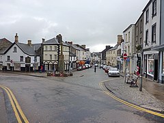
 Market Street, Ulverston |
|
| Ulverston shown within Cumbria | |
| Population | 11,678 (2011) |
| Demonym | Ulverstonian |
| OS grid reference | SD2878 |
| Civil parish |
|
| District | |
| Shire county | |
| Region | |
| Country | England |
| Sovereign state | United Kingdom |
| Post town | ULVERSTON |
| Postcode district | LA12 |
| Dialling code | 01229 |
| Police | Cumbria |
| Fire | Cumbria |
| Ambulance | North West |
| EU Parliament | North West England |
| UK Parliament | |
Ulverston is a market town and civil parish in the South Lakeland district of Cumbria in North West England. Historically in Lancashire, the town is in the Furness area around 8 miles (13 kilometres) north-east of Barrow-in-Furness. It is close to the Lake District, and just north of Morecambe Bay, neighboured by Swarthmoor, Pennington and Rosside.
Ulverston's most visible landmark is Hoad Monument, a concrete structure built in 1850 to commemorate statesman and local resident Sir John Barrow. The monument provides scenic views of the surrounding areas, including Morecambe Bay and parts of the Lake District.
Ulverston Canal, which is no longer navigable, was once a vital component of the town's economy.
The town is home to many shops and pubs, some on the stone paved main street, Market Street. At the head of the street is a war memorial to soldiers who died in the First World War.
Ulverston is a comparatively large civil parish. It is bounded in the east by the Leven estuary, Crake, Coniston Water and Yewdale Beck. To the west the boundary follows a chain of hills, and beyond that lie the towns of Kirkby-in-Furness and Askam and Ireleth. To the south is relatively low land, but it rises quickly. In the north are hills such as Coniston Old Man. The settlements of the parish are mainly concentrated in the eastern part.
...
Wikipedia

