Pike of Blisco
| Pike of Blisco | |
|---|---|

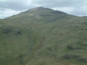
Pike of Blisco from the ridge of Wet Side Edge, between the Three Shire Stone and Great Carrs
|
|
| Highest point | |
| Elevation | 705 m (2,313 ft) |
| Prominence | 177 m (581 ft) |
| Parent peak | Scafell Pike |
| Listing | Marilyn, Hewitt, Wainwright, Nuttall |
| Coordinates | 54°25′41″N 3°07′31″W / 54.42798°N 3.12519°WCoordinates: 54°25′41″N 3°07′31″W / 54.42798°N 3.12519°W |
| Geography | |
| Location | Cumbria, England |
| Parent range | Lake District, Southern Fells |
| OS grid | NY271042 |
| Topo map | OS Landrangers 89, 90, Explorer OL6 |
Pike of Blisco, or Pike o' Blisco, is a mountain in the Lake District in Cumbria, England. Located between the valleys of Great Langdale and Little Langdale, its relative isolation from neighbouring fells together with slopes falling away immediately from the summit in all directions mean it has excellent views: the view of the Langdale Pikes across Great Langdale is particularly arresting.
The name Pike of Blisco is the form used on Ordnance Survey maps. The influential guidebook writer A. Wainwright preferred Pike o' Blisco (he refers to Pike of Blisco as its "Sunday name"), and wrote, "the man has no blood in his veins who does not respond eagerly to its fine-sounding, swashbuckling name".
Pike of Blisco stands on the complex ridge of high ground descending south-eastward from the Scafell massif. The ridge incorporates Esk Pike, Bow Fell, Crinkle Crags and Cold Pike before turning sharply north-eastward to Pike of Blisco; it then makes a further abrupt northerly diversion around Blea Tarn to connect to Lingmoor Fell. To the north of Pike of Blisco is the Oxendale branch of Great Langdale, while Little Langdale stands to the south east. The two valleys drain eastward, joining beyond Lingmoor Fell. To the south of Pike of Blisco is the 393 m (1,290 ft) summit of Wrynose Pass, which links Little Langdale with the Duddon Valley, and beyond the pass lies Swirl How and the Coniston Fells.
...
Wikipedia

