Black Creek, Toronto
|
Jane and Finch Elia, University Heights |
|
|---|---|
| Neighbourhood | |

Sunrise at the Jane Finch Mall
|
|
| Location within Toronto | |
| Coordinates: 43°45′26″N 79°31′4″W / 43.75722°N 79.51778°WCoordinates: 43°45′26″N 79°31′4″W / 43.75722°N 79.51778°W | |
| Country |
|
| Province |
|
| City |
|
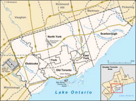
Jane and Finch is a neighbourhood located in the northwest end of Toronto, Ontario, Canada, in the district of North York. Centred at the intersection of Jane Street and Finch Avenue West, the area is roughly bounded by Highway 400 to the west, Driftwood Avenue to the east, Grandravine Drive to the south, and Shoreham Drive to the north. It is a neighbourhood compromised mostly of visible minorities.
The community has one of the largest concentrations of criminal gangs of any area in Canada. It also has "one of the highest proportions of youth, sole-supported families, refugees and immigrants, low-income earners and public housing tenants of any community in Toronto”. As of 2002, only 70% of people in the neighbourhood had proper indoor plumbing (compared to 95% of Canadians), and brownouts were common. Over half of the neighbourhood's residents live below the poverty line: In 2006, 53.18% of the working population earned less than $20,000 per year, increasing to 54.14% by 2011.
The neighbourhood is made up of single-family detached and semi-detached houses, along with a large number of high-rise apartment buildings.
As part of a rebranding strategy in 2008, Toronto City Councillor Anthony Perruzza had banners attached to hundreds of hydro poles in Jane and Finch, calling the area University Heights.
Jane-Finch was originally developed as a model suburb in the 1960s in response to the rapid urban growth of Toronto. The community was planned to accommodate a socially diverse population and included a substantial amount of public housing, but insufficient thought was given to the social infrastructure needed to sustain community life. (A historical name for the general area from 1878 to 1956 was Elia).
...
Wikipedia

