Bistrița-Năsăud County
|
Bistrița-Năsăud County Județul Bistrița-Năsăud |
||
|---|---|---|
| County | ||

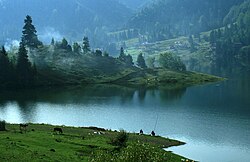
Colibița Lake, Bistrița-Năsăud County
|
||
|
||
 Location of Bistrița-Năsăud County in Romania |
||
| Country |
|
|
| Development region1 | Nord-Vest | |
| Historic region | Transylvania | |
| Capital city (Reședință de județ) | Bistrița | |
| Government | ||
| • Type | County Board | |
| • President of the County Council | Liviu Rusu | |
| • Prefect2 | Nastasia Bob | |
| Area | ||
| • Total | 5,355 km2 (2,068 sq mi) | |
| Area rank | 26th in Romania | |
| Population (2011) | ||
| • Total | 277,861 | |
| • Rank | 35th in Romania | |
| • Density | 52/km2 (130/sq mi) | |
| Time zone | EET (UTC+2) | |
| • Summer (DST) | EEST (UTC+3) | |
| Postal Code | 42wxyz3 | |
| Area code(s) | +40 x634 | |
| Car Plates | BN5 | |
| GDP | US$ 2.31 billion (2008) | |
| GDP/capita | US$ 7,391 (2008) | |
| Website |
County Council County Prefecture |
|
|
1The developing regions of Romania have no administrative role, but were formed in order to manage funds from the European Union 2 as of 2007, the Prefect is not a politician, but a public functionary. He (or she) is not allowed to be a member of a political party, and is banned from having any political activity in the first six months after resigning (or being excluded) from the public functionaries' corps. 3w, x, y, and z are digits that indicate the city, the street, part of the street, or even the building of the address 4x is a digit indicating the operator: 2 for the former national operator, Romtelecom, and 3 for the other ground telephone networks 5used on both the plates of the vehicles that operate only in the county limits (like utility vehicles, ATVs, etc.), and the ones used outside the county |
||
Bistrița-Năsăud (Romanian pronunciation: [ˈbistrit͡sa nəsəˈud]) is a county (județ) of Romania, in Transylvania, with the capital city at Bistrița.
In Hungarian, it is known as Beszterce-Naszód megye, and in German as Kreis Bistritz-Nassod. During the Hungarian administration, from 1876 to 1918 and from 1940 to 1944, there was a county with similar name (see: Beszterce-Naszód County). Between 1925 and 1940 and between 1945 and 1950, most of its territory belonged to the Năsăud County, with smaller parts belonging to the Mureș, Cluj and Someș counties.
In October 31, 2011, it had a population of 277,861 and the population density was 51/km².
83.1% of inhabitants were Romanian Orthodox, 6.3% Pentecostal, 4.6% Reformed, 2.3% Greek-Catholic, 1.2% Roman Catholic, 0.8% Baptist, 0.7% belonged to "another religion", 0.5% Seventh-day Adventist and 0.5% other or none.
The county has a total area of 5,355 km². One third of this surface represents the mountains from the Eastern Carpathians group: the Țibleș, Rodna, Bârgău and Călimani Mountains. The rest of the surface represents the North-East side of the Transylvanian Plateau.
...
Wikipedia

