Biliran Island
| Biliran | ||
|---|---|---|
| Province | ||
| Province of Biliran | ||
|
||
 Location in the Philippines |
||
| Coordinates: 11°35′N 124°29′E / 11.58°N 124.48°ECoordinates: 11°35′N 124°29′E / 11.58°N 124.48°E | ||
| Country | Philippines | |
| Region | Eastern Visayas (Region VIII) | |
| Founded | 11 May 1992 | |
| Seat | Naval | |
| Government | ||
| • Type | Sangguniang Panlalawigan | |
| • Governor | Gerardo Espina, Jr (Liberal) | |
| • Vice Governor | Eriberto Tubis, Jr. (Liberal) | |
| Area | ||
| • Total | 536.01 km2 (206.95 sq mi) | |
| Area rank | 78th out of 81 | |
| Highest elevation (Mount Biliran) | 1,340 m (4,400 ft) | |
| Population (2015 census) | ||
| • Total | 171,612 | |
| • Rank | 75th out of 81 | |
| • Density | 320/km2 (830/sq mi) | |
| • Density rank | 21st out of 81 | |
| Divisions | ||
| • Independent cities | 0 | |
| • Component cities | 0 | |
| • Municipalities | ||
| • Barangays | 132 | |
| • Districts | Lone district of Biliran | |
| Time zone | PHT (UTC+8) | |
| ZIP code | 6560–6567 | |
| IDD : area code | +63 (0)53 | |
| ISO 3166 code | PH-BIL | |
| Spoken languages | ||
| Website | biliran |
|

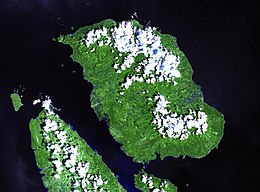
NASA Landsat image of Biliran
|
|
| Geography | |
|---|---|
| Location | Samar Sea |
| Coordinates | 11°31′23″N 124°32′06″E / 11.523°N 124.535°E |
| Archipelago | Visayas |
| Area | 555.4 km2 (214.4 sq mi) |
| Highest elevation | 1,340 m (4,400 ft) |
| Administration | |
|
Philippines
|
|
Biliran (Cebuano: Lalawigan sa Biliran; Waray-Waray: Probinsya han Biliran; Filipino: Lalawigan ng Biliran) is an island province in the Philippines located in the Eastern Visayas region (Region VIII). Biliran is one of the country's smallest and newest provinces. Formerly a sub-province of Leyte, it became an independent province in 1992.
Biliran lies less than a kilometer north of the island of Leyte. A bridge-causeway fixed link over Poro Island connects the province to Leyte. Its capital is the municipality of Naval on the western coast of the island.
During the early Spanish era, what is now called Biliran Island was known as Isla de Panamao. The present name, believed to be adopted sometime between the late 17th century and the early 18th century, was, according to many publications, derived from a native grass called borobiliran which once grew abundantly on the island's plains. A contending theory states that the name came from the word bilir, which was defined in an old Visayan dictionary to be the “corner or edge of a boat, vase or anything protruding, like veins, or the furrow made by the plow.” The dictionary also gives biliran as an alternate spelling for bilir. This theory is supported by the fact that Biliran was site of the first large-scale shipyard, built in the 17th century. Galleons were built to support the Galleon trade between Manila and Acapulco in Mexico.
...
Wikipedia

