Biebergemünd
| Biebergemünd | ||
|---|---|---|

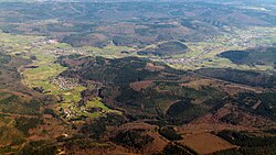
The southern part of the municipality, seen from the southwest
|
||
|
||
| Coordinates: 50°12′25″N 9°16′47″E / 50.20694°N 9.27972°ECoordinates: 50°12′25″N 9°16′47″E / 50.20694°N 9.27972°E | ||
| Country | Germany | |
| State | Hesse | |
| Admin. region | Darmstadt | |
| District | Main-Kinzig-Kreis | |
| Government | ||
| • Mayor | Manfred Weber | |
| Area | ||
| • Total | 78.55 km2 (30.33 sq mi) | |
| Population (2015-12-31) | ||
| • Total | 8,384 | |
| • Density | 110/km2 (280/sq mi) | |
| Time zone | CET/CEST (UTC+1/+2) | |
| Postal codes | 63599 | |
| Dialling codes | 06050 | |
| Vehicle registration | MKK | |
| Website | www.biebergemuend.de | |
Biebergemünd is a municipality in the Main-Kinzig district, in Hesse, Germany. It has a population of over 8,000 and lies in the wooded hills of the Spessart.
The name derives from the River Bieber, which flows (mündet) into the Kinzig at Wirtheim.
Biebergemünd is mostly located in the Hessian part of the Spessart at elevations between 140 and 250 metres above NHN. Around 70% of the municipal territory is covered by forest. In the north, the municipality extends into the valley of the Kinzig river.
The municipality's territory borders on the state of Bavaria in the south. The neighbouring communities are (from the north, clockwise): Wächtersbach, Bad Orb, Jossgrund, Flörsbachtal, Wiesener Forst, Geiselbacher Forst and Huckelheimer Wald (three wooded gemeindefreie Gebiete, Bavaria), Kleinkahl (Bavaria), Linsengericht and Gelnhausen.
Biebergemünd has the following subdivisions (Ortsteile, population numbers for 2013):
Pre-historic hillforts were located on several hills in the area. Those on the hills Burgberg (Bieber), Alteburg (Kassel) and Hainkeller (Lützel) are attributed to the Celts, or more specifically to the late Hallstatt and early La Tène cultures, circa 540 to 340 BC. Although the reason for this concentration of Iron Age settlements in this area is not known, it may be associated with the presence of ores and mining activities (see below).
...
Wikipedia


