Białystok Voivodeship (1919–1939)
| Białystok Voivodeship Województwo białostockie |
|||||
| Voivodeship of Poland | |||||
|
|||||
|
Coat of arms |
|||||
|
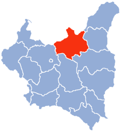
Location of the Białystok Voivodeship (red) within the Second Polish Republic, 1938. |
|||||
| Capital | Białystok | ||||
| Government | Voivodeship | ||||
| Voivode | |||||
| • | 1919–1920 | Stefan Badzynski | |||
| • | 1937–1939 | Henryk Ostaszewski | |||
| History | |||||
| • | Established | 14 August 1919 | |||
| • | Annexed | September 1939 | |||
| Area | |||||
| • | 1921 | 32,450 km2(12,529 sq mi) | |||
| • | 1939 | 26,036 km2(10,053 sq mi) | |||
| Population | |||||
| • | 1921 | 1,305,284 | |||
| Density | 40.2 /km2 (104.2 /sq mi) | ||||
| • | 1931 | 1,263,300 | |||
| Political subdivisions | 13 counties (powiaty) (1919–38) 10 counties (1938–1939) |
||||
See also: Białystok Voivodeship (1945–1975) and Białystok Voivodeship (1975–1998)
Coat of arms
Białystok Voivodeship (Polish: Województwo białostockie) was an administrative unit of interwar Poland (1918–1939). The province's capital and its biggest city was Białystok with the population of over 91,000 people. Following the Nazi German and the Soviet invasion of Poland, the Voivodeship was occupied by both invading armies and divided according to Nazi-Soviet boundary treaty.
In interwar Poland (1918–1939), Bialystok Voivodeship was located in mid-northern part of the country. It bordered Germany (East Prussia) to north-west, Lithuania to north-east, Wilno Voivodeship and Nowogródek Voivodeship to the east, Polesie Voivodeship and Lublin Voivodeship to the south and Warsaw Voivodeship to the west. Its area was 26 036 km². Landscape was flat, with the mighty Bialowieza Forest located right in the middle.
Inhabited mostly by Poles (in 1931 they made up 66.9% of the population), it also had significant Belarusian (16.3%) and Jewish (12.1%) minorities. Interesting is the fact that in 1931, 2.8% claimed Russian as their native tongue. The population, according to the 1931 Polish census was 1 263 300.
...
Wikipedia

