Lublin Voivodeship (1919–1939)
| Lublin Voivodeship Wojewodztwo lubelskie |
|||||
| Voivodeship of Poland | |||||
|
|||||
|
Coat of arms |
|||||
|
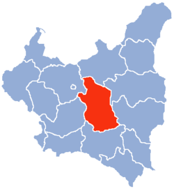
Location of the Lublin Voivodeship (red) within the Second Polish Republic, 1938. |
|||||
| Capital | Lublin | ||||
| Government | Voivodeship | ||||
| Voivode | |||||
| • | 1919–1926 | Stanisław Moskalewski | |||
| • | 1937–1939 | Jerzy Albin de Tramecourt | |||
| History | |||||
| • | Established | 14 August 1919 | |||
| • | Terrtiorial changes | 1 April 1938 | |||
| • | Annexed by Germany | September 1939 | |||
| Area | |||||
| • | 1921 | 31,123 km2(12,017 sq mi) | |||
| • | 1939 | 26,555 km2(10,253 sq mi) | |||
| Population | |||||
| • | 1921 | 2,087,951 | |||
| Density | 67.1 /km2 (173.8 /sq mi) | ||||
| • | 1931 | 2,116,200 | |||
| Political subdivisions | 16 powiats, 29 cities | ||||
Coat of arms
Lublin Voivodeship (Polish: Województwo Lubelskie) was a unit of administrative division of the Second Polish Republic between the two world wars, in the years 1919–1939. The province's capital and biggest city was Lublin.
The Voivodeship was founded by the decree of Polish Parliament Sejm of 14 August 1919. In the years 1919–1939 (unlike today), Lublin Voivodeship covered the central part of interwar Poland – the heartland of the country – bordering Białystok Voivodeship (1919–39) to the north, Warsaw Voivodeship and Kielce Voivodeship to the west, Lwów Voivodeship to the south and Polesie Voivodeship as well as Volhynian Voivodeship to the east. Its area, after April 1, 1938 (see: Territorial changes of Polish Voivodeships on April 1, 1938) was 26,555 km². Landscape was flat and hilly in the south, forests covered only 16.6% of the area (with nation's average of 22.2%, as for January 1, 1937).
According to the Polish census of 1921 which was the First General Census in the Second Polish Republic following World War I (conducted by the Main Bureau of Statistics, see originals), the population of Lublin Voivodeship could be categorized by both location and religious beliefs in the following way.
...
Wikipedia


