Białołęka
| Białołęka | |||
|---|---|---|---|
| Dzielnica of Warsaw | |||

Światowida street in 2007
|
|||
|
|||
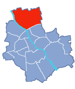
 Location of Białołęka within Warsaw |
|||
| Coordinates: 52°19′15.60″N 20°58′13.80″E / 52.3210000°N 20.9705000°ECoordinates: 52°19′15.60″N 20°58′13.80″E / 52.3210000°N 20.9705000°E | |||
| Country |
|
||
| Voivodeship | Masovian | ||
| County/City | Warsaw | ||
| Government | |||
| • Mayor | Piotr Jaworski | ||
| Area | |||
| • Total | 73.04 km2 (28.20 sq mi) | ||
| Population (2011) | |||
| • Total | 92,768 | ||
| • Density | 1,300/km2 (3,300/sq mi) | ||
| Time zone | CET (UTC+1) | ||
| • Summer (DST) | CEST (UTC+2) | ||
| Area code(s) | +48 22 | ||
| Website | bialoleka.waw.pl | ||
Białołęka (Polish pronunciation: [bʲawɔˈwɛŋka], from biały - white and łąka - meadow) is one of 18 districts of Warsaw, located in the northern part of the city. Until October 27, 2002 Białołęka was a gmina. The name Białołęka comes from a nobleman Białołęcki, who bought the area before the First World War.
According to the Central Statistical Office data, the district's area is 73.04 square kilometres (28.20 square miles) and 92 768 people inhabit Białołęka.
On the fields of Białołęka, one of the battles with the Swedish on July 28–30, 1656 took place. On February 25, 1831 one of the battles of the November Uprising - Battle of Białołęka - took place.
The area of the division is subdivided into following parts:
Białołęka is divided into smaller subdivisions (osiedles). Here's a list of them (the italic names are the ones which are not taken into account by the TERYT).
...
Wikipedia


