Bethel Heights, Arkansas
| Bethel Heights, Arkansas | |
|---|---|
| City | |
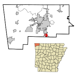
 Location in Benton County and the state of Arkansas |
|
| Coordinates: 36°13′22″N 94°7′40″W / 36.22278°N 94.12778°WCoordinates: 36°13′22″N 94°7′40″W / 36.22278°N 94.12778°W | |
| Country | United States |
| State | Arkansas |
| County | Benton |
| Area | |
| • Total | 2.39 sq mi (6.19 km2) |
| • Land | 2.37 sq mi (6.15 km2) |
| • Water | 0.02 sq mi (0.04 km2) |
| Elevation | 1,348 ft (411 m) |
| Population (2010) | |
| • Total | 2,372 |
| • Density | 1,000/sq mi (386.0/km2) |
| Time zone | Central (CST) (UTC-6) |
| • Summer (DST) | CDT (UTC-5) |
| FIPS code | 05-05740 |
| GNIS feature ID | 0076320 |
| Website | www |
Bethel Heights is a city in Benton County, Arkansas, United States. The population was 2,372 at the 2010 census, up from 714 at the 2000 census. It is part of the Fayetteville–Springdale–Rogers, AR-MO Metropolitan Statistical Area.
Bethel Heights is located in southern Benton County at 36°13′22″N 94°7′40″W / 36.22278°N 94.12778°W (36.222843, -94.127671). It is bordered by Springdale to the east, south, and west, and by Lowell to the north. U.S. Route 71 (Thompson Street) runs north–south along the western side of the city, and Arkansas Highway 264 runs east–west through the center of the city.
According to the United States Census Bureau, the city has a total area of 2.4 square miles (6.2 km2), of which 0.015 square miles (0.04 km2), or 0.69%, is water.
As of 2010 Bethel Heights had a population of 2,372. The racial and ethnic composition of the population was 49.7% non-Hispanic white, 1.9% black or African American, 1.4% Native American, 3.0% Asian, 8.3% Pacific Islander, 21.6% from some other race, 2.2% from two or more races and 34.7% Hispanic or Latino.
...
Wikipedia
