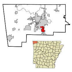
Lowell, Arkansas
| Lowell, Arkansas | ||
|---|---|---|
| City | ||

City Hall
|
||
|
||
 Location in Arkansas |
||
| Coordinates: 36°15′38″N 94°8′22″W / 36.26056°N 94.13944°WCoordinates: 36°15′38″N 94°8′22″W / 36.26056°N 94.13944°W | ||
| Country | United States | |
| State | Arkansas | |
| County | Benton | |
| Incorporated | 1881 | |
| Government | ||
| • Mayor | Eldon Long | |
| Area | ||
| • Total | 9.2 sq mi (23.9 km2) | |
| • Land | 9.2 sq mi (23.7 km2) | |
| • Water | 0.08 sq mi (0.2 km2) | |
| Elevation | 1,342 ft (409 m) | |
| Population (2010) | ||
| • Total | 7,327 | |
| • Density | 801/sq mi (309.3/km2) | |
| Time zone | Central (UTC-6) | |
| • Summer (DST) | Central (UTC-5) | |
| ZIP code | 72745 | |
| Area code(s) | 479 | |
| FIPS code | 05-41720 | |
| GNIS feature ID | 0077562 | |
| Website | www |
|
Lowell is a city in Benton County, Arkansas, in the United States. Located within the Ozarks, first settlement was along Old Wire Road in the 1840s, and although destroyed during the Civil War, the community was reestablished by J. H. McClure and thrived when the St. Louis–San Francisco Railway came through the area in the 1880s. Today, the city is a growing bedroom community within the rapidly growing Northwest Arkansas region. Lowell is also home to the headquarters of trucking company J.B. Hunt. Lowell's population was 7,327 at the 2010 census, an increase of 46% since 2000.
According to the United States Census Bureau, Lowell has a total area of 9.2 square miles (23.9 km2), of which 9.2 square miles (23.7 km2) is land and 0.077 square miles (0.2 km2), or 0.68%, is water. Lowell is located in southern Benton County at 36°15′38″N 94°8′22″W / 36.26056°N 94.13944°W (36.260429, -94.139570). It is bordered by the cities of Springdale and Bethel Heights to the south, Cave Springs to the west and Rogers to the north. 4 miles (6 km) to the east is Beaver Lake, a large reservoir of the White River.
...
Wikipedia

