Bereg (county)
| Bereg County Comitatus Bereghiensis (Latin) Bereg vármegye (Hungarian) Komitat Bereg (German) |
|||||
| County of the Kingdom of Hungary | |||||
|
|||||
|
Coat of arms |
|||||
| Capital |
Beregszász 48°12′N 22°39′E / 48.200°N 22.650°ECoordinates: 48°12′N 22°39′E / 48.200°N 22.650°E |
||||
| History | |||||
| • | Established | 12th century | |||
| • | Treaty of Trianon | June 4, 1920 | |||
| Area | |||||
| • | 1910 | 3,786 km2(1,462 sq mi) | |||
| Population | |||||
| • | 1910 | 236,611 | |||
| Density | 62.5 /km2 (161.9 /sq mi) | ||||
| Today part of |
|
||||
| Berehove is the current name of the capital. | |||||
Coat of arms
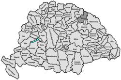
Bereg (Rusyn: Береґ; German: Berg) was an administrative county (comitatus) of the Kingdom of Hungary. Its territory is now in northeastern Hungary and western Ukraine. The capital of the county was Beregszász ("Berehove" in Ukrainian, Berehovo in Rusyn, Bergsaß in German, Beregovo in Russian, Bereg in Romanian).
Bereg county shared borders with the Austrian crownland Galicia (now in Poland and Ukraine) and the Hungarian counties Máramaros, Ugocsa, Szatmár, Szabolcs and Ung. It was situated between the Carpathian Mountains in the north and the river Tisza in the south. Its area was 3788 km² around 1910.
Bereg is one of the oldest counties in Hungary. In 1920 the Treaty of Trianon assigned most of the territory to Czechoslovakia. The southwestern part remained in Hungary (county Szatmár-Ugocsa-Bereg).
...
Wikipedia


