Belfry, MT
| Belfry, Montana | |
|---|---|
| Census-designated place | |

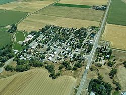
Aerial view of Belfry
|
|
 Location of Belfry, Montana |
|
| Coordinates: 45°8′29″N 109°0′28″W / 45.14139°N 109.00778°WCoordinates: 45°8′29″N 109°0′28″W / 45.14139°N 109.00778°W | |
| Country | United States |
| State | Montana |
| County | Carbon |
| Area | |
| • Total | 1.72 sq mi (4.45 km2) |
| • Land | 1.66 sq mi (4.31 km2) |
| • Water | 0.05 sq mi (0.14 km2) |
| Elevation | 3,862 ft (1,177 m) |
| Population (2010) | |
| • Total | 218 |
| • Density | 131/sq mi (50.6/km2) |
| Time zone | Mountain (MST) (UTC-7) |
| • Summer (DST) | MDT (UTC-6) |
| ZIP code | 59008 |
| Area code(s) | 406 |
| FIPS code | 30-04900 |
| GNIS feature ID | 0802021 |
Belfry is a census-designated place (CDP) in Carbon County, Montana, United States. It is part of the Billings, Montana Metropolitan Statistical Area. The population was 218 at the 2010 census. It is located approximately 11 miles (18 km) from the Wyoming border, roughly halfway between Billings, Montana and Cody, Wyoming.
Belfry is predominantly an agricultural community. The primary crops are sugar beets, alfalfa, and feed corn. Ranchers raise cattle and sheep. Water for agricultural use comes mostly from the Clarks Fork of the Yellowstone River through several cooperative ditch companies, with water rights dating back 100 years or more.
At its peak in the early 1900s, a railway line came into Belfry, with a spur running up to the coal mines in Bearcreek. When the mines closed down and the railway line was removed, Belfry's population dropped to its current level. Currently, the community has a general store, a bar, a restaurant, and a small bar/restaurant/casino.
Belfry is located in south-central Carbon County at 45°8′29″N 109°0′28″W / 45.14139°N 109.00778°W (45.141506, -109.007779).
...
Wikipedia
