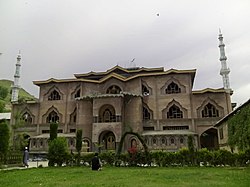
Beerwah, Jammu and Kashmir
|
Beerwah,Kashmir بیروہ बीरवाह Beerwah |
|
|---|---|
| City | |

Jamia Masjid Beerwah
|
|
| Location in Jammu and Kashmir | |
| Coordinates: 34°00′47″N 74°35′42″E / 34.013°N 74.595°ECoordinates: 34°00′47″N 74°35′42″E / 34.013°N 74.595°E | |
| Country |
|
| Territories of India | Jammu and Kashmir |
| District | Budgam |
| Area | |
| • Total | 4,950 km2 (1,910 sq mi) |
| Population (2016) | |
| • Total | 167,850 |
| • Density | 34/km2 (88/sq mi) |
| Languages | |
| • Official | Urdu |
| Time zone | IST (UTC+5:30) |
| Vehicle registration | JK04 |
Beerwah, (Urdu, بیروہ) Jammu and Kashmir is a Sub-District in Central Kashmir. It is one of the oldest tehsils with one of the largest constituency, towns, and municipal areas committees in the Budgam district of the Indian administered Jammu and Kashmir. Beerwah is known as The Gateway of Tosamaidan.
The name Beerwah has been derived from a Sanskrit word "Behroop" which means land of springs.This is due to the abundance of natural springs in the area.Beerwah has seven springs in the town area.
Beerwah is located at a height of 5200 ft above sea level, between 75° E longitude and 34° N latitude at the base of the Pir Panjal mountain range. It is surrounded by plains to the north, east, south, and southwest. The town is flanked by a mountain range on its southern side. At the eastern super of this mountain is located the celebrated cave connected with life of Acharya Abinav Gupta, the greatest Shiva philoiopher of Kashmir. The Acharya was called Bhairwa. The celebrated cave is located at the height of nearly 300 meter on the super of the ridge overlooking the crescent shaped narrow valley of evergreen Jungles with a Sukh Nag Nalla flowing through it. The landscape is made up of plateau-like terraces known as karewas.
The region contains forested areas with several mountain rivers and streams, including the Mala Kol, Lear Kol, Ahij Kol, Laen, Zaen, Mean and Sona Mean. The Ahij Kol, Laen and Sona Maen share a source at Sukhnag. The Mala Kol is locally known as the "deaf and dumb stream" due to a legend that when saint Syed Taj-ud-Din arrived in Khag, the stream silently followed him from Sukhnag to Sikandarpora. Local elders continue to tell stories about other local streams.
Tosamaidan is a large pasture with a historical background. Bounded by dense forests of deodars, it is situated about 10 km from Khag in the Himalayas. Many countries' shepherds used to visit the area in ancient times, and it was a frequent route for Mughals travelling to Poonch and Punjab. Today the area is frequently used by local shepherds and the Gujjar community.
...
Wikipedia


