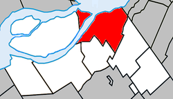
Beauharnois, Quebec
| Beauharnois | |
|---|---|
| City | |
 |
|
 Location within Beauharnois-Salaberry RCM |
|
| Location in southern Quebec | |
| Coordinates: 45°19′N 73°52′W / 45.32°N 73.87°WCoordinates: 45°19′N 73°52′W / 45.32°N 73.87°W | |
| Country |
|
| Province |
|
| Region | Montérégie |
| RCM | Beauharnois-Salaberry |
| Constituted | January 1, 2002 |
| Government | |
| • Mayor | Claude Haineault |
| • Federal riding | Salaberry—Suroît |
| • Prov. riding | Beauharnois |
| Area | |
| • Total | 83.70 km2 (32.32 sq mi) |
| • Land | 69.09 km2 (26.68 sq mi) |
| Population (2011) | |
| • Total | 12,011 |
| • Density | 173.9/km2 (450/sq mi) |
| • Pop 2006-2011 |
|
| • Dwellings | 5,585 |
| Time zone | EST (UTC−5) |
| • Summer (DST) | EDT (UTC−4) |
| Postal code(s) | J6N |
| Area code(s) | 450 and 579 |
| Highways |
|
| Website | ville |
Beauharnois is a city located in the Beauharnois-Salaberry Regional County Municipality of southwestern Quebec, Canada, and is part of the Greater Montreal Area. The city's population as of the Canada 2011 Census was 12,011. It is home to the Beauharnois Hydroelectric Power Station, one of the largest hydroelectric generating stations in the world, as well as the Beauharnois Lock of the Saint Lawrence Seaway.
As part of the 2000–2006 municipal reorganization in Quebec, the neighbouring towns of Maple Grove and Melocheville were amalgamated into Beauharnois on January 1, 2002.
The following locations reside within the municipality's boundaries:
The following waterways pass through or are situated within the municipality's boundaries:
In 2012, OVH started construction of its first Canadian data centre in Beauharnois, one of the largest in the world.
...
Wikipedia

