Baugh Fell
| Baugh Fell | |
|---|---|

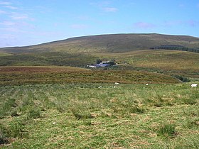
The slopes of Baugh Fell from Grisedale
|
|
| Highest point | |
| Elevation | 678 m (2,224 ft) |
| Prominence | c. 260 m |
| Parent peak | Wild Boar Fell |
| Listing | Marilyn, Hewitt, Nuttall |
| Coordinates | 54°19′11″N 2°24′02″W / 54.319767°N 2.400445°WCoordinates: 54°19′11″N 2°24′02″W / 54.319767°N 2.400445°W |
| Geography | |
|
|
|
| Parent range | Pennines |
| OS grid | SD740916 |
| Topo map | OS Landranger 98, Explorer OL19 |
Baugh Fell (/boʊˈfɛl/, /bɔːˈfɛl/ or locally /ˈbɑːfəl/) is a large, flat-topped hill in the northern Pennines of England. It lies in the north-western corner of the Yorkshire Dales National Park, immediately to the east of the Howgill Fells and to the north of Whernside, the highest of the Yorkshire Three Peaks. Formerly in the West Riding of Yorkshire, since 1974 it has been part of the county of Cumbria.
Baugh Fell is bounded by Garsdale to the south and by the valley of the River Rawthey to the west; on the north-eastern side it adjoins Swarth Fell and Wild Boar Fell. The fell sprawls over a wide area, roughly 45 square kilometres (17 sq mi) in size, with generally steep slopes on the Garsdale side and gentler slopes to the west. The Rawthey rises high up on the summit plateau (where it is called Rawthey Gill) and initially flows north, before turning south to form the hill's western boundary. The eastern limit of the fell is marked by Grisedale Beck, the main tributary of the Clough River which flows through Garsdale.
...
Wikipedia

