Garsdale
| Garsdale | |
|---|---|
 Garsdale |
|
| Garsdale shown within Cumbria | |
| Population | 191 (2011) |
| OS grid reference | SD7489 |
| Civil parish |
|
| District | |
| Shire county | |
| Region | |
| Country | England |
| Sovereign state | United Kingdom |
| Post town | SEDBERGH |
| Postcode district | LA10 |
| Dialling code | 015396 |
| Police | Cumbria |
| Fire | Cumbria |
| Ambulance | North West |
| EU Parliament | North West England |
| UK Parliament | |
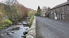
Garsdale is a dale or valley in the south east of Cumbria, England, on the western slopes of the Pennines, between Baugh Fell to the north, and Rise Hill to the south. It is within the Yorkshire Dales National Park. The dale is the valley of the Clough River, which rises on the north eastern slopes of Baugh Fell and flows through Grisedale, the Dale that Died, as Grisedale Beck until it becomes the Clough River at Garsdale Head.
The dale forms the civil parish of Garsdale (though the last mile and a half of the course of the Clough river, before its confluence with the Rawthey, is part of the parish of Sedbergh). Small settlements lie along the main Northallerton to Kendal road (the A684) which runs through the dale for 7 miles (11 km), with frequent bridges in the upper part of the dale. The largest settlement, known as “The Street”, lies 6 miles (9.7 km) east of Sedbergh, and 10 miles (16 km) west of Hawes. The other hamlet in Garsdale is Garsdale Head, also called Hawes Junction, the old name for Garsdale railway station, after the former Wensleydale branch on the Settle to Carlisle railway. The population of the parish recorded in the 2001 census was 202, with many of the 150 houses being derelict or used as second homes.
Garsdale was historically a part of the West Riding of Yorkshire, and was transferred to Cumbria in 1974. It is now within the South Lakeland local government district, but is still a "Yorkshire Dale" for planning purposes.
...
Wikipedia

