Whernside
| Whernside | |
|---|---|

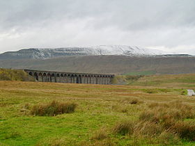
A snow-covered Whernside and Ribblehead
Viaduct seen from Ribblehead |
|
| Highest point | |
| Elevation | 736 m (2,415 ft) |
| Prominence | 408 m (1,339 ft) |
| Parent peak | Cross Fell |
| Listing | Marilyn, Hewitt, Hardy, County Top, Nuttall |
| Coordinates | 54°13′40″N 2°24′12″W / 54.22764°N 2.40338°WCoordinates: 54°13′40″N 2°24′12″W / 54.22764°N 2.40338°W |
| Geography | |
|
|
|
| OS grid | SD738814 |
| Topo map | OS Landranger 98 |
Whernside is a mountain in the Yorkshire Dales in Northern England. It is the highest of the Yorkshire Three Peaks, the other two being Ingleborough and Pen-y-ghent. It is the highest point in the ceremonial county of North Yorkshire and the historic West Riding of Yorkshire with the summit lying on the county border with Cumbria.
In shape Whernside forms a long ridge, running roughly north-north-east to south-south-west. The mountain is 6.2 miles (10 km) north west of Ingleton and 6.2 miles (10 km) north of Horton-in-Ribblesdale.
There is a right of way footpath running from the east at Ribblehead that heads north via Smithy Hill and Grain Ings before turning west to Knoutberry Haw and then south to Whernside itself. From the summit the right of way heads initially south, then steeply southwest down a stepped path to the area known as Bruntscar. If climbed as part of the Yorkshire Three Peaks Challenge (which is normally done anti-clockwise) Whernside will be climbed following the route up from Ribblehead to descend to Bruntscar.
There are, however, other routes up/down the mountain which are not rights of way.
A path heads directly west from the triangulation pillar to reach the road that is Deepdale Lane near White Shaw Moss.
An alternative route heads directly north across Knoutberry Haw to pass Whernside Tarns and reaches the Craven Way at Boot of the Wold.
...
Wikipedia

