Battle of Tarakan (1945)
| Battle of Tarakan (1945) | |||||||
|---|---|---|---|---|---|---|---|
| Part of the Pacific Theatre of World War II | |||||||
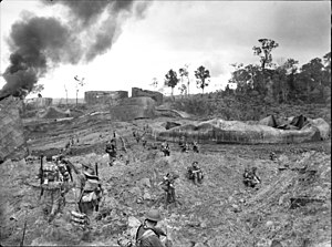
 Australian infantry advancing through wrecked oil storage tanks at Tank Hill, Tarakan. |
|||||||
|
|||||||
| Belligerents | |||||||
|
|
|
||||||
| Commanders and leaders | |||||||
|
|
Tadai Tokoi | ||||||
| Strength | |||||||
| 15,532 | 2,200 | ||||||
| Casualties and losses | |||||||
| 251+ dead, 669+ wounded |
1,540 dead, 252 captured prior to 15 August 1945 |
||||||
| At least 100 civilians killed or wounded | |||||||
The Battle of Tarakan was the first stage in the Borneo campaign of 1945. It began with an amphibious landing by Australian forces on 1 May, code-named Operation Oboe One. While the battle ended with success for the Allied forces over the Japanese defenders, this victory is generally regarded as having not justified its costs.
Tarakan is a triangle-shaped island 2.5 miles (4.0 km) off the coast of Borneo. The island is roughly 15 miles (24 km) long from its northernmost point to the southern tip and 11 miles (18 km) wide towards the north of the island. The small island of Sadau is located about 0.5 miles (0.80 km) off Tarakan's west coast. Almost all of Tarakan's coastline is swampy, and in 1945 mangroves on the northern half of the island stretched 1 mile (1.6 km) to 2 miles (3.2 km) inland. The coastal mangroves in the southern portion of the island were narrower. Inland from the swamps, most of central Tarakan comprised a series of steep and densely forested hills just over 100 feet (30 m) high. Tarakan is located three degrees north of the equator and has a tropical climate. The maximum temperature for most days is about 80 °F (27 °C), and relative humidity is consistently high at about 90 percent.
In 1945, Tarakan Town was the main settlement of the island. This town was located 2,000 yards (1,800 m) inland, and was separated from the south-west coast by several small hills covered in low vegetation. Four piers used to dock oil tankers were located on this coastline at the settlement of Lingkas, and were connected to Tarakan Town by three surfaced roads. Tarakan airfield was located about 1 mile (1.6 km) north-west of Tarakan Town. Of the island's two oilfields, Sesanip Oilfield was located at the north-east edge of the airfield while the larger Djoeata or Juata Oilfield was 3 miles (4.8 km) to the north. The village of Djoeata was located on Tarakan's north-west coast and linked to Djoeata Oilfield by a track.
Prior to World War II, Tarakan formed part of the Netherlands East Indies (NEI) and was an important oil production centre. The island's two oilfields produced 80,000 barrels of oil per month in 1941. Securing Tarakan's oilfields formed one of Japan's early objectives during the Pacific War. Japanese forces landed on the island's east coast on 11 January 1942 and defeated the small Dutch garrison in two days of fighting in which half the defenders were killed. While the oilfields were successfully sabotaged by the Dutch before their surrender, Japanese engineers were able to swiftly restore them to production and 350,000 barrels were extracted each month by early 1944.
...
Wikipedia
