Battle of Tarakan (1942)
| Battle of Tarakan | |||||||
|---|---|---|---|---|---|---|---|
| Part of World War II | |||||||
 Tarakan island |
|||||||
|
|||||||
| Belligerents | |||||||
|
|
|
||||||
| Commanders and leaders | |||||||
|
|
|
||||||
| Strength | |||||||
| Over 6,600 | Over 1,300 | ||||||
| Casualties and losses | |||||||
| 255 killed | Unknown number killed in battle. 219 executed after surrendering. 871 prisoners. |
||||||
The Battle of Tarakan took place on January 11–12, 1942, beginning a day after the Empire of Japan declared war on the Kingdom of the Netherlands. Although Tarakan was only a small marshy island off northeastern Borneo in the Netherlands East Indies, the island's 700 oil wells, oil refinery, and airfield made it a crucial objective for Japan in the Pacific War.
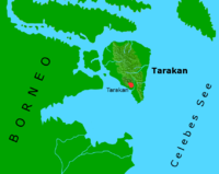
Tarakan is a triangle shaped island 2.5 miles (4.0 km) off the coast of Borneo. The island is roughly 15 miles (24 km) long from its northernmost point to the southern tip and 11 miles (18 km) wide towards the north of the island. The small island of Sadau is located about 0.5 miles (0.80 km) off Tarakan's west coast. Almost all of Tarakan's coastline is swampy, and in 1945 mangroves on the northern half of the island stretched 1 to 2 miles (1.6 to 3.2 km) inland. The coastal mangroves in the southern portion of the island were narrower. Inland from the swamps, most of central Tarakan comprised a series of steep and densely forested hills just over 100 feet (30 m) high. Tarakan is located three degrees north of the equator and has a tropical climate. The maximum temperature for most days is about 90 degrees Fahrenheit, and relative humidity is consistently high at about 90%.
In 1945, Tarakan Town was the main settlement of the island. This town was located 2,000 yards (1,800 m) inland, and was separated from the south-west coast by several small hills covered in low vegetation. Four piers used to dock oil tankers were located on this coastline, and were connected to Tarakan Town by three surfaced roads. Tarakan airfield was located about 1 mile (1.6 km) north-west of Tarakan Town. Of the island's two oilfields, Sesanip Oilfield was located at the north-east edge of the airfield while the larger Djoeata or Juata Oilfield was 3 miles (4.8 km) to the north. The village of Djoeata was located on Tarakan's north-west coast and linked to Djoeata Oilfield by a track.
On January 10, 1942, after a Dutch Dornier Do 24K flying boat spotted an approaching Japanese invasion fleet, the commander of Tarakan's garrison ordered the destruction of all oil installations on the island.
...
Wikipedia
