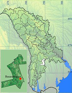
Basarabeasca district
| Basarabeasca | ||
|---|---|---|
| District (Raion) | ||
|
||
 |
||
| Country |
|
|
| Administrative center (Oraş-reşedinţă) |
Basarabeasca |
|
| Government | ||
| • Raion President | Ilie Cernăuţan (PCRM), since 2007 | |
| Area | ||
| • Total | 295 km2 (114 sq mi) | |
| Population (2014) | ||
| • Total | 23,012 | |
| • Density | 78/km2 (200/sq mi) | |
| Time zone | EET (UTC+2) | |
| • Summer (DST) | EEST (UTC+3) | |
| Postal Code | 297 | |
| Area code(s) | +373 67 | |
| Car plates | BS | |
| Website | http://basarabeasca.md/ | |
Basarabeasca is a district (Moldovan: raion) in the south of Moldova, with the administrative center at Basarabeasca.
From 1393 to 1538, the region was part of the principality of Moldavia. In the 16th, 17th and 18th centuries, the region was populated by Tatars. Localities with the oldest documentary attestation is Sadaclia, remembered the first time in 1793. In 1812, after the Russo-Turkish War (1806-1812), is the occupation of Basarabia, Russian Empire during this period (1812–1917), there is an intense russification of the native population. In 1918, after the collapse of the Russian Empire, Bessarabia united with Romania in this period (1918–1940, 1941–1944), the district is part of the Tighina County. In 1940 after Molotov-Ribbentrop Treaty, Basarabia is occupied by the USSR. In 1991 as a result of the proclamation of Independence of Moldova, part and residence of the Lapusna County (1991–2003), and in 2003 became administrative unit of Moldova.
District is located in the southern part of the Republic of Moldova. Neighborhood has the following district: north Cimislia District, the east boundary of the state with Ukraine, in the west and south bordering of Gagauzia. Also the district is the smallest area and population of Moldova was. The landscape of the field with maximum altitudes of 210–220 m with a mild erosion processes.
...
Wikipedia

