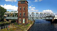
Barton, Salford, Greater Manchester
| Barton-upon-Irwell | |
|---|---|
 The Barton Swing Aqueduct carries the Bridgewater Canal over the Manchester Ship Canal. |
|
|
Barton-upon-Irwell shown within Greater Manchester
|
|
| Population | 12,462 (2001 Census) |
| OS grid reference | SJ762978 |
| Metropolitan borough | |
| Metropolitan county | |
| Region | |
| Country | England |
| Sovereign state | United Kingdom |
| Post town | MANCHESTER |
| Postcode district | M30 |
| Dialling code | 0161 |
| Police | Greater Manchester |
| Fire | Greater Manchester |
| Ambulance | North West |
| EU Parliament | North West England |
| UK Parliament | |
| Councillors |
|
Barton-upon-Irwell (also known as Barton-on-Irwell or Barton) is a suburban area of Salford, Greater Manchester, England, with a population of 12,462 in 2014.
Barton Old Hall, a brick-built house degraded to a farmhouse, was the seat of the Barton, Booth and Leigh families. The church of St Catherine, built in stone with an octagonal spire rising to 100 feet (30 m), was consecrated in 1843. The church was demolished in the 1970s due to dry rot and the parish was merged with the neighbouring church of St Michael & All Angels, Peel Green.
Historically in Lancashire, Barton-upon-Irwell was a township in the ecclesiastical parish of Eccles in the hundred of Salford. Barton was joined with the municipal borough of Eccles in 1933 which was at the time part of the Lancashire administrative county. Eccles joined the City of Salford, Greater Manchester in 1974. Barton-upon-Irwell is currently represented in Westminster by Barbara Keeley MP for Worsley and Eccles South.
The ward is represented by three councillors:
indicates seat up for re-election.
Barton lay about 5.5 miles (8.9 km) southwest of Manchester on both banks of the River Irwell from Trafford Park to Davyhulme and included the hamlet of Dumplington, now the site of the Trafford Centre. The Irwell was the boundary as far as the River Mersey, which with the Glazebrook were also boundaries.
...
Wikipedia

