Glazebrook
| Rixton-with-Glazebrook | |
|---|---|
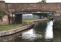
 Bridge 161, Trent and Mersey Canal |
|
| Rixton-with-Glazebrook shown within Cheshire | |
| Population | 1,884 (2001 Census) |
| OS grid reference | SJ697925 |
| Civil parish |
|
| Unitary authority | |
| Ceremonial county | |
| Region | |
| Country | England |
| Sovereign state | United Kingdom |
| Post town | WARRINGTON |
| Postcode district | WA3 |
| Dialling code | 01925 |
| Police | Cheshire |
| Fire | Cheshire |
| Ambulance | North West |
| EU Parliament | North West England |
| UK Parliament | |
| Website | Warrington Villages |
Rixton-with-Glazebrook is a civil parish in the unitary authority of Warrington, Cheshire, England. Historically part of Lancashire, it lies to the east of Warrington and borders Irlam, and is largely farmland. It has a railway station at Glazebrook and is served by buses along the A57 road. The parish was originally a township within Warrington parish before becoming a separate parish in 1866. It was part of the Warrington Poor Law Union and, from 1894, Warrington Rural District, and the District of Warrington from 1974.
According to the 2001 Census, Rixton-with-Glazebrook parish had a population of 1,884.
Glazebrook has a small housing estate, a post office and Glazebrook railway station. The station, on the Liverpool to Manchester southern route, marks the westernmost boundary of the Transport for Greater Manchester area.
The village lies around 4 miles east of Warrington town centre and is bounded by Cadishead to the east and Culcheth to the north.
The name "Rixton" derives from the personal name "Ric" and , which is Old English for a homestead or settlement. "Glazebrook" derives from glas, which can mean either a river, or else "blue" or "green or blue", and , from Old English "brōc", meaning a small stream.
...
Wikipedia

