Balakan Rayon
| Balakən | |
|---|---|
| Rayon | |

The international border crossing from Georgia to Balakan
|
|
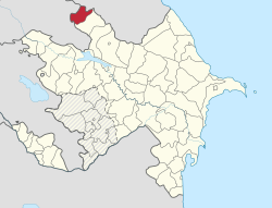
 Map of Azerbaijan showing Balakan Rayon |
|
| Country | Azerbaijan |
| Established | 8 August 1930 |
| Capital | Balakən |
| Area | |
| • Total | 920 km2 (360 sq mi) |
| Population (2010) | |
| • Total | 90,300 |
| • Density | 98/km2 (250/sq mi) |
| Postal code | 0800 |
| Telephone code | (+994) 24 |
Balakan (Azerbaijani: Balakən) is a rayon of northwestern Azerbaijan, located between Georgia and Russia. It borders Georgia to south and west and Dagestan of Russia to east and north. There is an Azerbaijan-Georgia border crossing at Postbina in the rayon that is open to both local residents and foreigners.
Archaeological finds including many historical monuments and kurgans in the region speak of early human habitation. Balakan was a part of Caucasian Albania. The Èrs also inhabited this region along with the rest of north-west Azerbaijan. A Greek writer of the time who authored books on the battle between the Roman troops and Caucasian Albanians on the bank of Alazani (Qanıx) river in 65 AD., described the locals as calm, prideful and full of courage. Etymology of names such as "Getovlar" (similar to Hettax), Hunbulanchay (similar to Huns), Ingiloy (similar to Gellah) and others confirm habitation of the region by early nomadic Turkic tribes. In the 7th century Balakan was invaded by Arabs and Balakən settlement was destroyed. After the Arab rule was overthrown in 9th–10th centuries, Balakan established its political and economic links with Shaki. Both provinces developed sericulture as their primary industry.
In 1803 the Balakan Rayon territory was incorporated into the Russian Empire and was administratively a part of Georgia until 1842, after that it was a separate oblast. In 1844 the Char-Balakan Military Region was founded. From 1860 to the end of the Russian Empire it was a part of Georgia within the Tiflis Governorate.
...
Wikipedia
