Bahnhofsviertel (Frankfurt am Main)
| Bahnhofsviertel | |
|---|---|
| Stadtteil of Frankfurt am Main | |
| Coordinates: 50°06′06″N 08°39′34″E / 50.10167°N 8.65944°ECoordinates: 50°06′06″N 08°39′34″E / 50.10167°N 8.65944°E | |
| Country | Germany |
| State | Hesse |
| Admin. region | Darmstadt |
| District | Urban district |
| Town | Frankfurt am Main |
| Area | |
| • Total | 0.525 km2 (0.203 sq mi) |
| Population (2007-12-31) | |
| • Total | 2,159 |
| • Density | 4,100/km2 (11,000/sq mi) |
| Time zone | CET/CEST (UTC+1/+2) |
| Postal codes | 60329 |
| Dialling codes | 069 |
| Vehicle registration | F |
| Website | www.bahnhofsviertel.de |
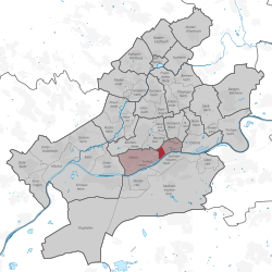
The Bahnhofsviertel (literally: train station quarter) is a city district of Frankfurt am Main, Germany. It is part of the Ortsbezirk Innenstadt I.
The Bahnhofsviertel was developed between 1891 and 1915. Along with the Westend, the Nordend and the Ostend, it is part of Frankfurt's dense inner city districts. The Bahnhofsviertel is known as one of Frankfurt's main entertainment and red-light districts (the latter esp. around Taunusstrasse), along with Alt-Sachsenhausen south of the river Main.
The Bahnhofsviertel is scarcely half a square kilometre larger than the Altstadt, making it the second smallest district of the city. The longest border line is just short of a kilometre long. Almost trapeze shaped, this districit lies between the Alleenring to the west, Mainzer Landstraße in the north and the Anlagenring to the east. The Main river forms a natural border in the south. Adjacent districts to the west are the Gutleutviertel and the Gallus around Frankfurt Central Station, the Westend in the north and the Innenstadt in the east. To the south, on the opposite side of the Main, lies Sachsenhausen.
The area between the Frankfurt city wall and field of the gallows had hardly been constructed by the early nineteenth century. Only farming estates were to be found in this area. Near to the city gallows and as an unprotected site outside the city walls, it was left alone for a long time. As industrialisation came in, the city walls and its gallows were torn down to be replaced initially by villas with large gardens. The technical advances were especially noticeable here. When in 1839 the Taunus Railway was built to the town of Höchst, still part of the Duchy of Nassau, the original Taunus station (Taunusbahnhof) was constructed on the Anlagenring. The track of the Taunus station ran through the middle of the district of today's station quarter. Later the stations of the Main-Neckar and Main-Weser lines were added to that. The western stations were grouped together until 1888, after which time they were replaced by the new Frankfurt central station, which was situated another 500m further west. Thus the railway tracks also became redundant, and the year 1889 was able to begin with a dividing up of the area. As there was still no significant residential zone existing in 1891, the area became the central site of the International Electro-Technical Exhibition led by Oskar von Miller. In the meantime, the large civil land development in the style of the Wilhelminian period was placed under monument protection. In the Second World War the quarter was not so strongly bombed as the inner city, but nevertheless many buildings were destroyed, particularly in the north. In the time of the occupation by the American armed forces the district developed an active nightlife, allowed soldiers free rein to endless brothels.
...
Wikipedia


