Mainzer Landstraße

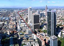
Mainzer Landstraße as seen from the Main Tower
|
|
| Length | 8.3 km (5.2 mi) |
|---|---|
| East end | Taunusanlage, Frankfurt Innenstadt |
| West end | Höchst |
| Construction | |
| Inauguration | 1750 |
Mainzer Landstraße is one of the main arterial roads in Frankfurt am Main, running west from the city centre to the outlying suburbs of the city. The road runs largely parallel with the River Main along its northern bank, and at 8.3 kilometres (5.2 mi) in length is Frankfurt's second longest road.
The road was built between 1746 and 1750 as part of the longer route between Frankfurt and Mainz. As one of the most heavily used roads in Frankfurt, factories soon sprang up along its length as Germany industrialised in the 19th century, including the headquarters of Adler and Tenovis. A tramway, the modern day lines 11 and 21, soon followed, supported by the industries along its length. By the outbreak of World War I, there were around 40 factories along the length of the road, with more along the many side roads that branch off it.
With the opening of Bundesautobahn 66, Mainzer Landstraße has become less important for long distance travel and now mostly facilitates travel around the west end of the city. Accordingly, it was downgraded from a regional road (Landesstraße) to a district road (Kreisstraße).
From the Innenstadt, Mainzer Landstraße runs through Westend, Bahnhofsviertel, Gallus, Griesheim and Nied on the way to Höchst.
...
Wikipedia
