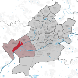
Höchst (Frankfurt am Main)
| Höchst | ||
|---|---|---|
| Stadtteil of Frankfurt am Main | ||
|
||
| Coordinates: 50°05′56″N 08°32′48″E / 50.09889°N 8.54667°ECoordinates: 50°05′56″N 08°32′48″E / 50.09889°N 8.54667°E | ||
| Country | Germany | |
| State | Hesse | |
| Admin. region | Darmstadt | |
| District | Urban district | |
| Town | Frankfurt am Main | |
| Area | ||
| • Total | 4.709 km2 (1.818 sq mi) | |
| Population (2007-12-31) | ||
| • Total | 13,723 | |
| • Density | 2,900/km2 (7,500/sq mi) | |
| Time zone | CET/CEST (UTC+1/+2) | |
| Postal codes | 65929 | |
| Dialling codes | 069 | |
| Vehicle registration | F | |
| Website | www.frankfurt.de | |
Höchst (German pronunciation: [ˈhøːkst] or [ˈhøːçst]) is a city district of Frankfurt am Main, Germany. It is part of the Ortsbezirk West.
Höchst am Main became part of Frankfurt am Main in 1928 together with its boroughs Sindlingen, Unterliederbach and Zeilsheim. It is situated 10 km west of downtown Frankfurt on the north bank of the Main river at the Nidda River estuary. The well-preserved old city has been under the Denkmalschutz protection law since 1972. An important cultural event is the folklore festival, the Höchster Schloßfest, that brings many visitors to Höchst. It begins in the middle of June and last four weeks. It includes a festival in the old city, fireworks, and a jazz festival in the castle.
In Höchst there is the Friedrich-Dessauer-Gymnasium, a sixth form Gymnasium.
Höchst is first mentioned in 790 as Hostat (meaning high site or high place). The name has nothing to do with the Hostato Saga regarding the Knight Hostato, who after being the only one to survive a battle was given the site by Charlemagne in thanks for his bravery. On February 11, 1355 Höchst received its town privileges by emperor Charles IV. In a charter dated January 12, 1356 Charles IV gave additional privileges to Höchst including the right to hold markets every Tuesday. In the middle-age city part, most of the timber framed houses stem from the period after the major fire in 1586.
...
Wikipedia


