Bad Sobernheim
| Bad Sobernheim | ||
|---|---|---|
 |
||
|
||
| Coordinates: 49°47′14″N 07°39′10″E / 49.78722°N 7.65278°ECoordinates: 49°47′14″N 07°39′10″E / 49.78722°N 7.65278°E | ||
| Country | Germany | |
| State | Rhineland-Palatinate | |
| District | Bad Kreuznach | |
| Municipal assoc. | Bad Sobernheim | |
| Government | ||
| • Mayor | Michael Greiner (SPD) | |
| Area | ||
| • Total | 54.06 km2 (20.87 sq mi) | |
| Elevation | 141-620 m (−1,893 ft) | |
| Population (2015-12-31) | ||
| • Total | 6,387 | |
| • Density | 120/km2 (310/sq mi) | |
| Time zone | CET/CEST (UTC+1/+2) | |
| Postal codes | 55566 | |
| Dialling codes | 06751 | |
| Vehicle registration | KH | |
| Website | www.bad-sobernheim.de | |
Bad Sobernheim is a town in the Bad Kreuznach district in Rhineland-Palatinate, Germany. It belongs to the like-named Verbandsgemeinde, and is also its seat. It is a state-recognized spa town, and is well known for two fossil discovery sites and for the naturopath Emanuel Felke. Bad Sobernheim is also a winegrowing town.
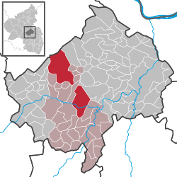
Bad Sobernheim lies on the middle Nahe about halfway between the district seat of Bad Kreuznach (roughly 20 km southwest of that town) and the gemstone town of Idar-Oberstein. Looming to the north is the Hunsrück, and to the south, the North Palatine Uplands. The municipal area stretches as far as the Soonwald. One notable feature of Bad Sobernheim’s municipal area is that it is split geographically into two non-contiguous pieces. The part to the southeast containing the main town holds most of the population, whereas the part to the northwest is only thinly populated, but nevertheless makes up more than half the town’s area. This came about as a result of the former Bundeswehr airfield in what is now the northwest part of the town. A great number of the people there chose to move house to Bad Sobernheim to escape the continual noise from aircraft, and the town annexed the land where they had formerly lived, up on the Nahe Heights. Since the residents of Nußbaum did not give their village up, Bad Sobernheim now has a great swathe of land to the northwest of its original municipal area, separated from it by Nußbaum's municipal area.
Clockwise from the north, Bad Sobernheim's neighbours are the municipalities of Waldböckelheim, Oberstreit, Staudernheim, Abtweiler, Lauschied, Meddersheim and Nußbaum. Bad Sobernheim also holds an outlying swathe of territory, not contiguous with the piece containing the actual town – Nußbaum lies between the two areas – and even greater in area, although very thinly populated. Its neighbours, again clockwise from the north, are the municipalities of Sargenroth, Winterbach, Ippenschied, Rehbach, Daubach, Nußbaum, Monzingen, Auen, Langenthal, Seesbach, Weitersborn, Schwarzerden and Mengerschied, the first and last of these both lying in the neighbouring Rhein-Hunsrück-Kreis (district).
...
Wikipedia


