Sargenroth
| Sargenroth | ||
|---|---|---|
|
||
| Coordinates: 49°55′56″N 7°30′54″E / 49.93222°N 7.51500°ECoordinates: 49°55′56″N 7°30′54″E / 49.93222°N 7.51500°E | ||
| Country | Germany | |
| State | Rhineland-Palatinate | |
| District | Rhein-Hunsrück-Kreis | |
| Municipal assoc. | Simmern | |
| Government | ||
| • Mayor | Gerd Martin | |
| Area | ||
| • Total | 12.71 km2 (4.91 sq mi) | |
| Elevation | 410 m (1,350 ft) | |
| Population (2015-12-31) | ||
| • Total | 438 | |
| • Density | 34/km2 (89/sq mi) | |
| Time zone | CET/CEST (UTC+1/+2) | |
| Postal codes | 55471 | |
| Dialling codes | 06761 | |
| Vehicle registration | SIM | |
| Website | www |
|
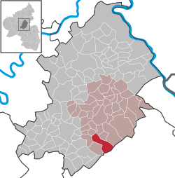
Sargenroth is an Ortsgemeinde – a municipality belonging to a Verbandsgemeinde, a kind of collective municipality – in the Rhein-Hunsrück-Kreis (district) in Rhineland-Palatinate, Germany. It belongs to the Verbandsgemeinde of Simmern, whose seat is in the like-named town.
The municipality lies in the central Hunsrück, between the Simmerbach valley and the Soonwald, a heavily wooded section of the west-central Hunsrück, roughly 8 km east of Kirchberg and 5 km south of Simmern. Sargenroth’s highest elevation is the Wildburghöhe, 629 m above sea level.
The placename ending —roth denotes the location of a clearing made for expanding fields or for settling. The name “Sargenroth” is recorded in the following spellings over the ages:
After 1706, the name was usually spelt with a G. The rootword is the Old High German rod and the Middle High German rot, meaning a place made tillable by clearing, or simply a clearing. The qualifier Sargen— might well go back to somebody named Saricho. Thus, the name would originally have meant “Saricho’s Clearing”.
There is a further idea, propounded by several people named at the source given here, that the name might once have been associated with a convent.
On 18 May 1276, Sargenroth had its first documentary mention when Pope Innocent V confirmed Tholey Abbey’s holdings. These had already been quite rich, but had been confined to the Abbey’s immediate area, Hermeskeil and Baumholder, but now some outlying holdings came its way, among them Sargenroth. The document mentions “lands in the village of Sargenhrucha”. Further documentary mentions are as follows:
...
Wikipedia


