Mengerschied
| Mengerschied | ||
|---|---|---|
|
||
| Coordinates: 49°54′51″N 7°30′41″E / 49.91417°N 7.51139°ECoordinates: 49°54′51″N 7°30′41″E / 49.91417°N 7.51139°E | ||
| Country | Germany | |
| State | Rhineland-Palatinate | |
| District | Rhein-Hunsrück-Kreis | |
| Municipal assoc. | Simmern | |
| Government | ||
| • Mayor | Hans Roller | |
| Area | ||
| • Total | 9.53 km2 (3.68 sq mi) | |
| Elevation | 330 m (1,080 ft) | |
| Population (2015-12-31) | ||
| • Total | 716 | |
| • Density | 75/km2 (190/sq mi) | |
| Time zone | CET/CEST (UTC+1/+2) | |
| Postal codes | 55490 | |
| Dialling codes | 06765 | |
| Vehicle registration | SIM | |
| Website | www |
|
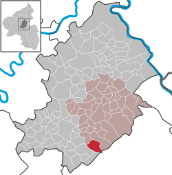
Mengerschied is an Ortsgemeinde – a municipality belonging to a Verbandsgemeinde, a kind of collective municipality – in the Rhein-Hunsrück-Kreis (district) in Rhineland-Palatinate, Germany. It belongs to the Verbandsgemeinde of Simmern, whose seat is in the like-named town.
The municipality lies at the foot of the Soonwald, a heavily wooded section of the west-central Hunsrück, in the valley of the Lametbach. The Lamet and the Brühlbach flow together in the village and thence towards the Kellenbach. Mengerschied lies roughly 7 km south of Simmern and 7 km southeast of Kirchberg. Its elevation is 325 m above sea level
Mengerschied is among the oldest places in the district. About 1080, Mengerschied had its first documentary mention as Mengezerodt. The name changed over the 15th and 16th centuries from Mengersroit to Mengersrade (1502), Mengerschitt (1584) and then Mengerschied (1785). The church named in the document was consecrated to the Apostles Philip and James and the holy virgin Saint Walpurga and was under the care of the Ravengiersburg Monastery. It was a parish church with baptismal rights, as witnessed to this day by the 15th-century baptismal font at the graveyard. The church itself became both the Protestants’ and the Catholics’ graveyard church after the Reformation, when the Protestants built their own church in the village. The graveyard church fell into disrepair during the 18th century.
...
Wikipedia


