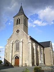
Béduer
| Béduer | |
|---|---|
| Commune | |

The church in Béduer
|
|
| Coordinates: 44°34′54″N 1°57′01″E / 44.5817°N 1.9503°ECoordinates: 44°34′54″N 1°57′01″E / 44.5817°N 1.9503°E | |
| Country | France |
| Region | Occitanie |
| Department | Lot |
| Arrondissement | Figeac |
| Canton | Figeac-Ouest |
| Intercommunality | Pays de Figeac-Cajarc |
| Government | |
| • Mayor (2008–2014) | Jean Hirondelle |
| Area1 | 24.78 km2 (9.57 sq mi) |
| Population (2009)2 | 730 |
| • Density | 29/km2 (76/sq mi) |
| Time zone | CET (UTC+1) |
| • Summer (DST) | CEST (UTC+2) |
| INSEE/Postal code | 46021 /46100 |
| Elevation | 176–405 m (577–1,329 ft) (avg. 260 m or 850 ft) |
|
1 French Land Register data, which excludes lakes, ponds, glaciers > 1 km² (0.386 sq mi or 247 acres) and river estuaries. 2Population without double counting: residents of multiple communes (e.g., students and military personnel) only counted once. |
|
1 French Land Register data, which excludes lakes, ponds, glaciers > 1 km² (0.386 sq mi or 247 acres) and river estuaries.
Béduer is a commune in the Lot department in southwestern France.
Béduer is situated on the Via Podiensis route that is followed by those making the pilgrimage to Santiago de Compostella and so receives pilgrims arriving from the town of Figeac.
From Béduer pilgrims continue on either to the Notre-Dame de l'Assomption church at Gréalou, reaching the Lot River at Cajarc, or follow the course of the River Célé to its confluence with the Lot, passing by the convent at Espagnac-Sainte-Eulalie.
The town was formerly owned by the Lostanges family. Its control of the land between the Lot and Célé rivers put it on a par with the Abbey at Figeac.
The Château de Barasc, situated on a ridge dates from the twelfth century and has been successively renovated over the ages. It was home to the Barasc family, one of whom, Gerald V, was Bishop of Cahors between 1237 and 1250.
...
Wikipedia


