Aura, Finland
| Aura | ||
|---|---|---|
| Municipality | ||
| Auran kunta | ||
|
||
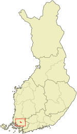
 Location of Aura in Finland |
||
| Coordinates: 60°39′N 022°35′E / 60.650°N 22.583°ECoordinates: 60°39′N 022°35′E / 60.650°N 22.583°E | ||
| Country |
|
|
| Region | Southwest Finland | |
| Sub-region | Loimaa sub-region | |
| Charter | 1917 | |
| Government | ||
| • Municipal manager | Jari Kesäniemi | |
| Area (2016-01-01) | ||
| • Total | 95.00 km2 (36.68 sq mi) | |
| • Land | 94.98 km2 (36.67 sq mi) | |
| • Water | 0.59 km2 (0.23 sq mi) | |
| Area rank | 301st largest in Finland | |
| Population (2016-03-31) | ||
| • Total | 3,980 | |
| • Rank | 203rd largest in Finland | |
| • Density | 41.9/km2 (109/sq mi) | |
| Population by native language | ||
| • Finnish | 98.1% (official) | |
| • Swedish | 0.5% | |
| • Others | 1.4% | |
| Population by age | ||
| • 0 to 14 | 21% | |
| • 15 to 64 | 65.9% | |
| • 65 or older | 13.1% | |
| Time zone | EET (UTC+2) | |
| • Summer (DST) | EEST (UTC+3) | |
| Municipal tax rate | 20.25% | |
| Climate | Dfb | |
| Website | www.aura.fi | |
Aura (Finnish pronunciation: [ˈɑurɑ]) is a municipality of Finland. The name derives from the river Aura and the plough (aura in Finnish) reminiscent shape of the municipality. The municipality was established in 1917 from parts of Lieto and Pöytyä.
It is part of the Varsinais-Suomi region. The municipality has a population of 3,980 (31 March 2016) and covers an area of 95.00 square kilometres (36.68 sq mi) of which 0.59 km2 (0.23 sq mi) is water. The population density is 41.9 inhabitants per square kilometre (109/sq mi).
The municipality is unilingually Finnish.
...
Wikipedia

