Aspisheim
| Aspisheim | ||
|---|---|---|
|
||
| Coordinates: 49°54′27″N 7°58′56″E / 49.90750°N 7.98222°ECoordinates: 49°54′27″N 7°58′56″E / 49.90750°N 7.98222°E | ||
| Country | Germany | |
| State | Rhineland-Palatinate | |
| District | Mainz-Bingen | |
| Municipal assoc. | Sprendlingen-Gensingen | |
| Government | ||
| • Mayor | Otto Kost | |
| Area | ||
| • Total | 5.81 km2 (2.24 sq mi) | |
| Elevation | 175 m (574 ft) | |
| Population (2015-12-31) | ||
| • Total | 899 | |
| • Density | 150/km2 (400/sq mi) | |
| Time zone | CET/CEST (UTC+1/+2) | |
| Postal codes | 55459 | |
| Dialling codes | 06727 | |
| Vehicle registration | MZ | |
| Website | www.aspisheim.de | |
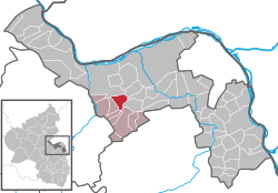
Aspisheim is an Ortsgemeinde – a municipality belonging to a Verbandsgemeinde, a kind of collective municipality – in the Mainz-Bingen district in Rhineland-Palatinate, Germany.
Aspisheim lies in Rhenish Hesse between Mainz and Bad Kreuznach. The municipality is administered by the Verbandsgemeinde of Sprendlingen-Gensingen, whose seat is in Sprendlingen.
The council is made up of 13 council members, counting the part-time mayor, with seats apportioned thus:
The municipality’s arms might be described thus: Per pale Or a yarn swift sable palewise and sable a lion rampant Or armed argent and langued gules.
On the next-to-last weekend in August the municipality’s residents stage the Rothesfest, a wine and street festival.
The municipality is crossed by the L 414 state road . The A 61 motorway runs roughly 4 km away from the municipality.
...
Wikipedia


