Ashford, Connecticut
| Ashford, Connecticut | ||
|---|---|---|
| Town | ||

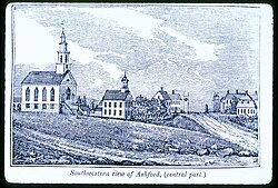
Center of town in 1838
|
||
|
||
 Location in Windham County and the state of Connecticut. |
||
| Coordinates: 41°53′N 72°10′W / 41.883°N 72.167°WCoordinates: 41°53′N 72°10′W / 41.883°N 72.167°W | ||
| Country | United States | |
| State | Connecticut | |
| NECTA | Hartford | |
| Region | Windham Region | |
| Incorporated | 1714 | |
| Government | ||
| • Type | Selectman-Town meeting | |
| • First Selectman | Michael J. Zambo (D) | |
| • Selectman | Ralph H. Fletcher (D) | |
| • Selectman | William A. Falletti (R) | |
| Area | ||
| • Total | 39.5 sq mi (102.3 km2) | |
| • Land | 38.8 sq mi (100.5 km2) | |
| • Water | 0.7 sq mi (1.8 km2) | |
| Elevation | 531 ft (162 m) | |
| Population (2005) | ||
| • Total | 4,416 | |
| • Density | 114/sq mi (44/km2) | |
| Time zone | Eastern (UTC-5) | |
| • Summer (DST) | Eastern (UTC-4) | |
| ZIP code | 06278 | |
| Area code(s) | 860 | |
| FIPS code | 09-01430 | |
| GNIS feature ID | 0213384 | |
| Website | www |
|
Ashford is a town in Windham County, Connecticut, United States. It is part of the Connecticut Quiet Corner. The population was 4,317 at the 2010 census. It was founded in 1714. Eastford was a part of Ashford until 1847, when the former split off to organize its own town. For this reason North Ashford is located in northeast Eastford.
Ashford is home to the largest boy scout camp in Connecticut, the June Norcross Webster Scout Reservation; to Paul Newman's Hole in the Wall Gang Camp for children with cancer and other serious illness; to the Salvation Army CONNRI Lodge and Conference Center; and to the Evangelical Christian Center, a retreat, camp and conference center.
President George Washington, returning from his tour of the country in the fall of 1789, was chagrined to be involuntarily abandoned in the village on a Sunday. It was contrary to law to hire a conveyance on that day, which was observed by villagers, to Washington's great annoyance.
New Ashford in Massachusetts is named after Ashford, as it was settled in 1762 by people from Ashford.
According to the United States Census Bureau, the town has a total area of 39.5 square miles (102 km2), of which, 38.8 square miles (100 km2) of it is land and 0.7 square miles (1.8 km2) of it (1.80%) is water. The Mount Hope River flows through the middle of the town, from north to south, while Bigelow Brook flows along the town's eastern border with Eastford. Ashford has several lakes and ponds, notably Ashford Lake, Lake Chaffee, Knowlton Pond, Rychlings Pond, Halls Pond, Poole Pond, and Morey Pond.
...
Wikipedia

