Ash Meadows
|
IUCN category IV (habitat/species management area)
|
|

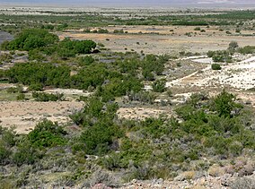
Ash Meadows habitat, in the Amargosa Desert.
|
|
|
Map of the United States
|
|
| Location | Nye County, Nevada, United States |
|---|---|
| Nearest city | Pahrump, Nevada |
| Coordinates | 36°25′30″N 116°20′00″W / 36.42500°N 116.33333°WCoordinates: 36°25′30″N 116°20′00″W / 36.42500°N 116.33333°W |
| Area | 23,000 acres (93 km2) |
| Established | 1984 |
| Governing body | U.S. Fish and Wildlife Service |
| Website | Ash Meadows National Wildlife Refuge |
| Designated | December 18, 1986 |
The Ash Meadows National Wildlife Refuge is a protected wildlife refuge located in the Amargosa Valley of southern Nye County, in southwestern Nevada. It is directly east of Death Valley National Park, and is 90 mi (140 km) west-northwest of Las Vegas.
The refuge was created on June 18, 1984 to protect an extremely rare desert oasis in the Southwestern United States. It is administered by the U.S. Fish and Wildlife Service.
The 23,000-acre (9,300 ha) Ash Meadows National Wildlife Refuge is part of the larger Desert National Wildlife Refuge Complex, which also includes: the Desert National Wildlife Refuge, the Moapa Valley National Wildlife Refuge, and the Pahranagat National Wildlife Refuge.
Ash Meadows is within the Amargosa Desert, of the Mojave Desert ecoregion. The Amargosa River is a visible part of the valley hydrology, and has seasonal surface flow passing southwards adjacent to the preserve, to later enter Death Valley.
Ash Meadows provides a valuable and unprecedented example of desert oases habitats, that have become extremely uncommon in the southwestern deserts. The refuge is a major discharge point for a vast underground aquifer water system, reaching more than 100 mi (160 km) to the northeast. Water-bearing strata come to the surface in more than thirty seeps and springs, providing a rich, complex variety of mesic habitats.
...
Wikipedia

