Artjärvi
|
Artjärvi Artsjö |
||
|---|---|---|
| Former municipality | ||
| Artjärven kunta | ||
|
||
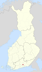
 Location of Artjärvi in Finland |
||
| Coordinates: 60°44.8′N 026°03.2′E / 60.7467°N 26.0533°ECoordinates: 60°44.8′N 026°03.2′E / 60.7467°N 26.0533°E | ||
| Country | Finland | |
| Region | Päijänne Tavastia | |
| Sub-region | Lahti sub-region | |
| Charter | 1865 | |
| Consolidated | 2011 | |
| Government | ||
| • Municipal manager | Kimmo Kuparinen | |
| Area | ||
| • Total | 197.33 km2 (76.19 sq mi) | |
| • Land | 177.01 km2 (68.34 sq mi) | |
| • Water | 20.32 km2 (7.85 sq mi) | |
| Population (2010-10-31) | ||
| • Total | 1,412 | |
| • Density | 7.98/km2 (20.7/sq mi) | |
| Population by native language | ||
| • Finnish | 97.8% (official) | |
| • Swedish | 0.8% | |
| • Others | 1.4% | |
| Population by age | ||
| • 0 to 14 | 14.1% | |
| • 15 to 64 | 59.7% | |
| • 65 or older | 26.2% | |
| Time zone | EET (UTC+2) | |
| • Summer (DST) | EEST (UTC+3) | |
| Climate | Dfb | |
| Website | www.artjarvi.fi | |
Artjärvi (Swedish: Artsjö) is a former municipality of Finland. It was consolidated with the town of Orimattila on January 1, 2011.
The municipality was located in the Päijänne Tavastia region. It had a population of 1,412 (31 October 2010) and covered a land area of 177.01 square kilometres (68.34 sq mi). The population density was 7.98 inhabitants per square kilometre (20.7/sq mi).
The municipality was unilingually Finnish.
...
Wikipedia

