Argeliers
| Argeliers | ||
|---|---|---|

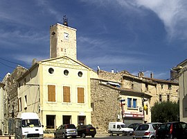
The Town Hall Square
|
||
|
||
| Coordinates: 43°19′00″N 2°55′00″E / 43.3167°N 2.9167°ECoordinates: 43°19′00″N 2°55′00″E / 43.3167°N 2.9167°E | ||
| Country | France | |
| Region | Occitanie | |
| Department | Aude | |
| Arrondissement | Narbonne | |
| Canton | Ginestas | |
| Intercommunality | Le Grand Narbonne | |
| Government | ||
| • Mayor (2014–2020) | Gilles Laur | |
| Area1 | 10.79 km2 (4.17 sq mi) | |
| Population (2009)2 | 1,683 | |
| • Density | 160/km2 (400/sq mi) | |
| Time zone | CET (UTC+1) | |
| • Summer (DST) | CEST (UTC+2) | |
| INSEE/Postal code | 11012 / 11120 | |
| Elevation | 26–220 m (85–722 ft) | |
|
1 French Land Register data, which excludes lakes, ponds, glaciers > 1 km² (0.386 sq mi or 247 acres) and river estuaries. 2Population without double counting: residents of multiple communes (e.g., students and military personnel) only counted once. |
||
1 French Land Register data, which excludes lakes, ponds, glaciers > 1 km² (0.386 sq mi or 247 acres) and river estuaries.
Argeliers is a French commune in the Aude department in the Occitanie region of southern France.
The inhabitants of the commune are known as Argeliésois or Argeliésoises
Argeliers is part of the urban area of Narbonne located on the southern edge of the Haut-Minervois and in the north of the fertile sedimentary plain of Narbonne, 22 km west by south-west of Béziers and 16 km north-west of Narbonne at the foot of the first foothills north of the plain of Narbonne. The northern border of the commune is the border between Aude and Hérault departments. Access to the commune is by the D5 road from Capestang in the east passing through the commune south of the village and continuing to Pouzols-Minervois in the west. Access to the village is by the D326 from Mirepeisset in the south intersecting the D5 and continuing to the village then north-east. The D36E48 comes from Montouliers in the north changing to the D426 at the border and continuing to join the D5 south-west of the village. The D826 also connects the village to the D5. The village residential area covers about a quarter of the commune with forests along the western border and the rest of the commune is farmland.
The Canal du Midi forms part of the eastern border of the commune passing through the commune east of the village where there are mooring facilities known as Port d'Argeliers. Other streams passing through the commune near the Canal include the Ruisseau des Gours and the Ruisseau de Roze.
On 11 March 1907 a signal for revolt was given by a group of Minervois winemakers in the village of Argeliers. They were led by Marcelin Albert and Élie Bernard who founded the Committee for the Defence of Wine-making or the Argeliers Committee. He organized a march with 87 winemakers to Narbonne for an interview with a parliamentary commission. After his depositions the defence committee went around the town singing for the first time La Vigneronne which from that day became the anthem of the Beggars' revolt.
...
Wikipedia


