Anzoátegui State
| Anzoátegui | |||
|---|---|---|---|
| State of Venezuela | |||

|
|||
|
|||
| Motto: Tumba de sus tiranos (English: Tomb of its tyrants) |
|||
| Anthem: Himno del Estado Anzoátegui | |||
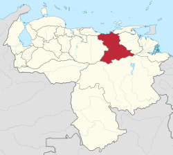
 Location within Venezuela |
|||
| Country | Venezuela | ||
| Created | 1909 | ||
| Capital | Barcelona | ||
| Government | |||
| • Governor | Nelson Moreno (2016) | ||
| Area | |||
| • Total | 43,300 km2 (16,700 sq mi) | ||
| Area rank | 6th | ||
| 4.72% of Venezuela | |||
| Population (2011 est.) | |||
| • Total | 1,469,747 | ||
| • Rank | 8th | ||
| 5.3% of Venezuela | |||
| Time zone | UTC-04:30 | ||
| ISO 3166 code | VE-B | ||
| Emblematic tree | Cereipo, or Guatamare (Myrospermum fructescens) | ||
| Website | www |
||
Anzoátegui State (Spanish: Estado Anzoátegui, IPA: [esˈtaðo ansoˈateɣi]) is one of the 23 component states of Venezuela, located in the northeastern region of the country. Anzoátegui is well known for its beaches that attract many visitors. Its coast consists of a single beach approximately 100 km long. Its capital is the city of Barcelona, and significant cities include Puerto la Cruz and El Tigre.
Named after the great hero of Venezuelan independence, José Antonio Anzoátegui (1789–1819), this state has its own history. The city of Barcelona, which is currently the state's capital, was founded in 1677. The present Anzoátegui State was included within the Cumaná Province, which was itself part of the Captaincy General of Venezuela, along with some other provinces (Guayana, Maracaibo, Caracas, Margarita and Trinidad). In 1810, it was separated from the province. It was in 1909 that it acquired the present political distribution.
Anzoátegui is located in the northeastern region of the country and is bordered by the states of Monagas and Sucre to the east, Bolivar to the south, Guarico to the west, Miranda to the northwest, and the Caribbean Sea to the north.
...
Wikipedia


