Andrews, Texas
| Andrews, Texas | ||
|---|---|---|
| City | ||
| City of Andrews | ||

Water tower
|
||
|
||
| Motto: "Move Ahead" | ||
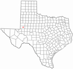
 Location of Andrews, Texas |
||
| Coordinates: 32°19′17″N 102°33′6″W / 32.32139°N 102.55167°WCoordinates: 32°19′17″N 102°33′6″W / 32.32139°N 102.55167°W | ||
| Country | United States | |
| State | Texas | |
| County | Andrews | |
| GovernmentCouncil-Manager | ||
| • Type | Elected(non-compensatory)Mayor-Council/ appointed City Manager | |
| • City Manager | Glen Hackler | |
| • Mayor | Flora Braly | |
| Area | ||
| • Total | 6.9 sq mi (18 km2) | |
| • Land | 6.9 sq mi (18 km2) | |
| • Water | 0.0 sq mi (0 km2) | |
| Elevation | 3,176 ft (968 m) | |
| Population (2010) | ||
| • Total | 11,088 | |
| • Estimate (2013) | 12,718 | |
| • Density | 1,600/sq mi (620/km2) | |
| Time zone | Central (CST) (UTC-6) | |
| • Summer (DST) | CDT (UTC-5) | |
| ZIP code | 79714 | |
| Area code(s) | 432 | |
| FIPS code | 48-03216 | |
| GNIS feature ID | 1329539 | |
| Website | www |
|
Andrews is a city in and the county seat of Andrews County in the State of Texas within the West Texas region. The population was 12,718 as of 2013.
Andrews was incorporated on February 2, 1937. Both the city and county were named for Richard Andrews, the first Texan soldier to die in the Texas Revolution.
Andrews is located at 32°19′17″N 102°33′6″W / 32.32139°N 102.55167°W (32.321401, -102.551733). The city has a total area of 6.9 square miles (18 km2), all land.
U.S. Highway 385 (north–south), State Highway 115 (east–west), and State Highway 176 (east–west) pass through Andrews.
Andrews Loop 1910 is a 13.1-mile-long (21.1 km), $12.5 million, city-maintained, ring road that through trucks are directed to follow. Although it is not a state highway, it is designated similar to a state highway loop, with a special blue shield. The number refers to the year Andrews County was organized, a name chosen after a citywide competition was held to name the new loop.
...
Wikipedia

