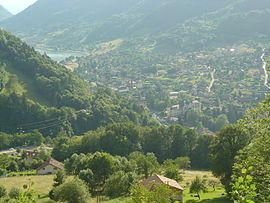
Allevard
| Allevard | ||
|---|---|---|
| Commune | ||

Allevard and the lake
|
||
|
||
| Coordinates: 45°23′40″N 6°04′29″E / 45.3944°N 6.0747°ECoordinates: 45°23′40″N 6°04′29″E / 45.3944°N 6.0747°E | ||
| Country | France | |
| Region | Auvergne-Rhône-Alpes | |
| Department | Isère | |
| Arrondissement | Grenoble | |
| Canton | Allevard | |
| Intercommunality | Pays du Grésivaudan | |
| Government | ||
| • Mayor (2014-2020) | Philippe Langénieux-Villard | |
| Area1 | 26 km2 (10 sq mi) | |
| Population (2014)2 | 4,131 | |
| • Density | 160/km2 (410/sq mi) | |
| Time zone | CET (UTC+1) | |
| • Summer (DST) | CEST (UTC+2) | |
| INSEE/Postal code | 38006 /38580 | |
| Elevation | 399–2,749 m (1,309–9,019 ft) | |
|
1 French Land Register data, which excludes lakes, ponds, glaciers > 1 km² (0.386 sq mi or 247 acres) and river estuaries. 2Population without double counting: residents of multiple communes (e.g., students and military personnel) only counted once. |
||
1 French Land Register data, which excludes lakes, ponds, glaciers > 1 km² (0.386 sq mi or 247 acres) and river estuaries.
Allevard, (also known as Allevard-les-Bains) is a French commune in the Isère department in the Auvergne-Rhône-Alpes region of southeastern France.
The inhabitants of the commune are known as Allevardins or Allevardines or alternatively as Allevardais or Allevardaises
The commune has been awarded two flowers by the National Council of Towns and Villages in Bloom in the Competition of Cities and Villages in Bloom.
Allevard is located in the Belledonne mountains 40 km south-east of Chambéry and 38 km north-east of Grenoble. The commune is accessed by the D525 from Goncelin in the south-west following the mountain ridge through the village and continuing north-east to La Chapelle-du-Bard. There are also some minor roads such as the D9 parallel to the D525 going to the north and the D108 which accesses the village from the D525. There is a tortuous mountain road - the D109 - which goes east of the village and eventually circles back to the north of the commune. The town has quite a large urban area in the west of the commune however the rest of the commune is mountainous and heavily forested.
The Bourg stream forms the southern boundary of the commune flowing west and the Buisson forms the northern boundary also flowing west. These streams together with numerous other streams flow into the Breda which flows north through the commune then west to join the Isère near Pontcharra.
There are several hamlets and localities in the commune. These are:
Blazon:
Gules, three bends argent, in chief the same charged with 3 bells azure with clappers of Or.
Allevard Castle stood above the town on a hill surrounded by a wall 60 toises long and described: "and water flowed from the Breyda and partly from the Sabaudie". The village was also fortified. Its enclosure was 1413 toises accessible through four doors. It was first mentioned in 1100. A large house on the edge of town, near Vingtain and the mill canals in 1367. A quoted recollection: "meniis Curtina et clausura".
...
Wikipedia


