Belledonne
| Belledonne | |
|---|---|

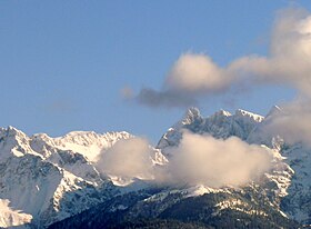
Clouds clear up and reveal Grand Pic de Belledonne
|
|
| Highest point | |
| Peak | Grand Pic de Belledonne |
| Elevation | 2,977 m (9,767 ft) |
| Coordinates | 45°03′N 5°48′E / 45.050°N 5.800°E |
| Dimensions | |
| Length | 60 km (37 mi) |
| Width | 10 km (6.2 mi) |
| Geography | |
| Country | France |
| Parent range | Dauphiné Alps |
Belledonne (French: La chaine de Belledonne) is a mountain range (French: massif) in the Dauphiné Alps (part of the French Alps) in southeast France. The southern end of the range forms the eastern wall of the mountains that surround the city of Grenoble.
The range is noted for the spectacular scenery it provides the inhabitants of Grenoble, numerous ski areas, interesting geology, and a diverse range of alpine land types and uses.
The Belledonne range is approximately 60 km (37 mi) long by between 10 km (6.2 mi) wide and runs from roughly 45°03′N 5°48′E / 45.050°N 5.800°E, 16 km (9.9 mi) south-south-east of the city of Grenoble, in a north-easterly direction (actually 35 degrees) for 65 km (40 mi) to roughly 45°33′N 6°17′E / 45.550°N 6.283°E, near the town of Aiguebelle. The highest point is the Grand Pic de Belledonne, 2,977 m (9,767 ft).
The range is delineated by several valleys which lie at relatively low altitude, including the Grésivaudan Valley (which carries the Isère River) on the west, the Arc River to the north and the Romanche River to the south. The range counts dozens of peaks over 2,500 m (8,200 ft), more than 10 glaciers, and many alpine lakes, the highest of which is over 2,400 m (7,900 ft) above sea level.
...
Wikipedia
