Alcácer do Sal Municipality
| Alcácer do Sal | |||
|---|---|---|---|
| Municipality | |||

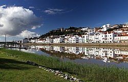
Alcácer do Sal, along the Sado River, showing the Reconquista Moorish Castle
|
|||
|
|||
 |
|||
| Coordinates: 38°22′21″N 8°30′49″W / 38.37250°N 8.51361°WCoordinates: 38°22′21″N 8°30′49″W / 38.37250°N 8.51361°W | |||
| Country |
|
||
| Region | Alentejo | ||
| Subregion | Alentejo Litoral | ||
| Intermunic. comm. | Alentejo Litoral | ||
| District | Setúbal | ||
| Parishes | 4 | ||
| Government | |||
| • President | Pedro Manuel Igrejas da Cunha Paredes (PS) | ||
| Area | |||
| • Total | 1,499.87 km2 (579.10 sq mi) | ||
| Elevation | 49 m (161 ft) | ||
| Population (2011) | |||
| • Total | 13,046 | ||
| • Density | 8.7/km2 (23/sq mi) | ||
| Time zone | WET/WEST (UTC+0/+1) | ||
| Postal code | 7580 | ||
| Area code | 265 | ||
| Patron | São João Baptiste | ||
| Website | http://www.cm-alcacerdosal.pt/ | ||
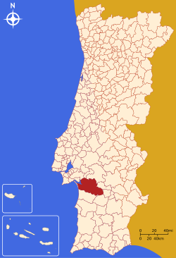
Alcácer do Sal (Portuguese pronunciation: [ɐɫˈkasɛɾ ðu ˈsaɫ]) is a municipality in Portugal, located in Setúbal District. The population in 2011 was 13,046, in an area of 1499.87 km².
There has been human settlement in the area for more than 40,000 years; archaeological investigations have placed human presence here back to the Mesolithic Period, when the first peoples began to concentrate in the areas around Alcácer. This period was characterized by exploitation of the ecosystem in the Sado Estuary, when the river extended to São Romão, involving fishing, scavenging for shellfish, hunting and foraging in the local forests. The primitive tools, made from chert, were adapted from the techniques of the late Paleolithic era. By the late Mesolithic period, people had concentrated in the area of Comporta and Torrão, later establishing primitive defensive protection to support its communities.
These principal settlements were abandoned by the Copper Age, but repopulated during the Iron Age, as was the case of Alcácer. Mediterranean trade, pioneered by the Phoenicians, introduced commercial colonies in Abul and Alcácer (then referred to as Bevipo or Keition), where a written alphabet and currency allowed commerce to flourish.
After the Third Punic War, with the fall of Carthage, Alcácer was annexed to the Roman Empire (around 1st-2nd century B.C.). The region of Alcácer became known as Urbs Imperatoria Salacia in honor of the nymph, and wife of Neptune, Salacia, for its importance in the Iberian salt trade and the number of routes that crossed the area. Salatia suffered many of the problems that developed from the Roman urbes localized between Atlantic routes and Romanized northern Europe, and was made incrementally worse by Claudius' initiatives into England and Wales. These problems changed during the 3rd Century, when the port of Salatia was devalued, in favor of Olisipo (Lisbon).
...
Wikipedia


