Alandroal Municipality
| Alandroal | |||
|---|---|---|---|
| Municipality | |||

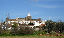
A profile of Alandroal showing the parochial church and low-lying buildings
|
|||
|
|||
 |
|||
| Coordinates: 38°37′12″N 7°24′29″W / 38.62000°N 7.40806°WCoordinates: 38°37′12″N 7°24′29″W / 38.62000°N 7.40806°W | |||
| Country |
|
||
| Region | Alentejo | ||
| Subregion | Alentejo Central | ||
| Intermunic. comm. | Alentejo Central | ||
| District | Évora | ||
| Parishes | 4 | ||
| Government | |||
| • President | João Maria Aranha Grilo (MUDA Movimento Unidade e Desenvolvimento de Alandroal) | ||
| Area | |||
| • Total | 542.68 km2 (209.53 sq mi) | ||
| Elevation | 341 m (1,119 ft) | ||
| Population (2011) | |||
| • Total | 5,843 | ||
| • Density | 11/km2 (28/sq mi) | ||
| Time zone | WET/WEST (UTC+0/+1) | ||
| Postal code | 7250 | ||
| Patron | Nossa Senhora da Boa Nova | ||
| Website | http://www.cm-alandroal.pt | ||
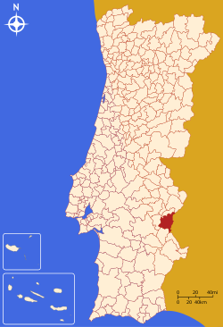
Alandroal (Portuguese pronunciation: [ɐlɐ̃dɾuˈaɫ]) is a municipality in the Portuguese district of Évora located on the eastern frontier with Spain along the right margin of the Guadiana River in the Central Alentejo region. It is located 341 metres (1,119 ft) above sea level, northeast of Évora and southeast of Estremoz. The population in 2011 was 5,843, in an area of 542.68 km².
With the completion of the castle in 1298, by Lourenço Afonso (9th Master of the Order of Aviz), the noble fulfilled his obligation to King Denis of Portugal to expand the territory that would form Alandroal. By 1359, the church of Alandroal was incorporated under the commander of the Order of Avis, but it was only a century later (1486) that John II would issue a foral (charter) for the town. Alandroal was elevated to town at this time, while only including the parish of Nossa Senhora da Conceição. A second foral was conceded in 1514 by his successor, Manuel I of Portugal.
Alandroal's historic importance include the medieval structures during the early period of Christian conquest, including the Castle of Alandroal (whose main gate was flanked by two towers); the Castle of Terena, consisting of wall-enclosed courtyard, keep and towers; the fortress of Juromenha, whose balusters were constructed later during the Portuguese Restoration War, but whose proximity to the Guadiana frontier provided a natural buttress to Castilian influence in the region.
The lands at the time, flowered with Nerium oleander shrubs and trees, whose wood was used by local artisans. Its Portuguese toponomy oleandro gave rise to the name aloendros or alandros, eventually alandroal.
...
Wikipedia


