Aka Hills
| Arunachal Pradesh | ||
|---|---|---|
| State | ||
|
||
 |
||
| Coordinates (Itanagar): 27°04′N 93°22′E / 27.06°N 93.37°ECoordinates: 27°04′N 93°22′E / 27.06°N 93.37°E | ||
| Country |
|
|
| Established | 20 February 1987 | |
| Capital | Itanagar | |
| Largest city | Itanagar | |
| Districts | 21 | |
| Government | ||
| • Body | Government of Arunachal Pradesh | |
| • Governor | Brig. (Dr.) B.D. Mishra (Retd.) | |
| • Chief Minister | Pema Khandu(BJP) | |
| • Legislature | Unicameral (60 seats) | |
| • Parliamentary constituency |
Rajya Sabha 1 Lok Sabha 2 |
|
| • High Court | Guwahati High Court - Itanagar Bench | |
| Area | ||
| • Total | 83,743 km2 (32,333 sq mi) | |
| Area rank | 15th | |
| Population (2011) | ||
| • Total | 1,382,611 | |
| • Rank | 27th | |
| • Density | 17/km2 (43/sq mi) | |
| Time zone | IST (UTC+05:30) | |
| ISO 3166 code | IN-AR | |
| HDI |
|
|
| HDI rank | 18th (2005) | |
| Literacy | 66.95% | |
| Official languages | ||
| Website | arunachalpradesh |
|
| Animal | Bos frontalis |
|---|---|
| Bird | Hornbill |
| Flower | Foxtail orchid |
| Tree | Hollong |
| Population Growth | |||
|---|---|---|---|
| Census | Pop. | %± | |
| 1961 | 337,000 |
—
|
|
| 1971 | 468,000 | 38.9% | |
| 1981 | 632,000 | 35.0% | |
| 1991 | 865,000 | 36.9% | |
| 2001 | 1,098,000 | 26.9% | |
| 2011 | 1,382,611 | 25.9% | |
| Source:Census of India First ever census was carried out in 1961. |
|||
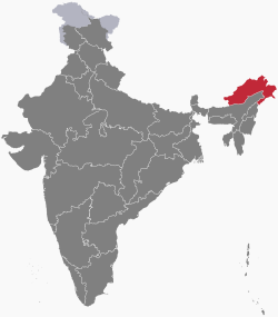
Arunachal Pradesh /ˌɑːrəˌnɑːtʃəl prəˈdɛʃ/ is one of the 29 states of India and is the northeastern-most state of the country. Arunachal Pradesh borders the states of Assam and Nagaland to the south and shares international borders with Bhutan in the west, Myanmar in the east and is separated from China in the north by the disputed McMahon Line. Itanagar is the capital of the state.
A major part of the state is claimed by the Republic of China, and the People's Republic of China referring to it as "South Tibet". The major part of the state which is claimed by China, was temporarily occupied by Chinese forces during the 1962 war.
Land of the Dawn-Lit Mountains is the sobriquet for the state in Sanskrit; it is also known as the Orchid State of India or the Paradise of the Botanists. Geographically, it is the largest of the North-eastern states known as the Seven Sister States. As in other parts of Northeast India, the people native to the state trace their origins to the Tibeto-Burman people.
...
Wikipedia

