Achada Furna
| Achada Furna | |
|---|---|

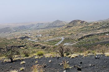
Panoramic view of the south of the island, on the left is Achada Furna and surrounding it are small hills.
|
|
| Coordinates: 14°52′23″N 24°21′32″W / 14.873°N 24.359°WCoordinates: 14°52′23″N 24°21′32″W / 14.873°N 24.359°W | |
| Country | Cape Verde |
| Island | Fogo |
| Municipality | Santa Catarina do Fogo |
| Civil parish | Santa Catarina do Fogo |
| Population (2010) | |
| • Total | 495 |
Achada Furna is a settlement in the southern part of the island of Fogo, Cape Verde. It is situated 15 km east of the island capital São Filipe. Its 2010 census population was 495 which is the municipality's third most populous. Its elevation is about 850 to 900 meters. Nearby places include Cabeça Fundão to the north, Figueira Pavão to the east, Fonte Aleixo to the south, Salto to the southwest and Monte Largo to the west. The municipal boundary with São Filipe is about a kilometer west of the village. Achada Furna are one of the most important places on the island and is the second important behind Cova Figueira and ahead of Chã das Caldeiras.
Its name etymology indicated that it is located on a volcanic plateau and the area affected by past lava flows. The area around Achada Furna and uphills are surrounded by smaller hills, once that were small volcanoes made out of the early eruptions up to as early as thousands or tens of thousands of years ago. Northeast of the village is a hill with a caldeira and is partly terraced.
Achada Furna is connected with a secondary road linking Monte Grande and Cova Figueira bypassing the capital and also is connected with the lesser road with Chã das Caldeiras, leastly used after the recent 2014-15 eruption, even probably some families from that village temporary living in a part of the village and the area. Aluguer buses connects Achada Furna but not on a fixed schedule during 6 days of the week but not on holidays, it once had a line that connected with Chã das Caldeiras, after the 2014-15 eruption, that line became eliminated. Southwest of the village on a small hill is a radio transmitter broadcasting in the south and east of Fogo.
Agriculture like other parts of that portion of the island is the key economy of the village.
Around 73,000 years ago, the area was formed as part of the interior of the earlier Fogo Mountain, the eastern half collapsed and with some erosion and lava flow over the centuries, thouth not as much as in the east and some small volcanoes, it would form the current landscape. From that point hundreds of meters west of modern day Achada Furna, it formed the line of where it collapsed, there, not much had collapsed in the area.
...
Wikipedia

